Saturday, April 25, 2009

04/25/2009 - Garrow's Bend

Launch: Causeway near the Triple Boat Ramps.
Route: Down the Tensaw, across to the Mobile River, down Mobile River to Arlington Channel and to Garrow’s Bend and back.
Distance: 21 miles.
Weather: Sunny, 75-85 degrees, winds calm to begin with then picking up to 10-15 mph in the afternoon. Current 1 to 2 mph in some river locations. High tide to tide going out in the afternoon.

Note to kayakers: Maximum ebb flow (tide going out) mixed with strong winds out of the south can cause unfriendly kayaking conditions in the deep river channels. Wave size can double or triple. It can be challenging at times to cross Mobile River south of McDuffie Island and the Tensaw River south of the Battleship. Be CAREFUL!


Header Image

1) Conditions were still foggy after giving it two hours to burn off.

2) Boats that have sunk for whatever reason, are left to rot and pollute the waters making it look like we live in a third world country trash dump.


3) White Pelican.

4) Brown Pelican.

5) Mobile Container Facility Crane. The last of the fog (seen on the horizon) was finally burning off.

6) Mobile Container Facility Dock on Mobile River.

7) Today’s kayak trip was to see if two major construction projects are harming local waters. On Mobile River, the waters were well protected by silt fences, haybales, fabrics, and booms at this dock construction (Austal expansion I think). Didn’t see any sign of erosion into Mobile River. Two thumbs up to the contractor on this site.

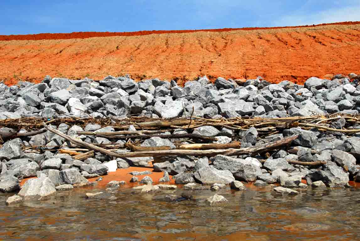
8) The Garrows Bend Intermodal Container Transfer Facility project by the Alabama State Port Authority was in pathetic condition. Mountains of red dirt and not a single erosion control method in most places with the exception of a boom out in the water. This photo shows red dirt eroding into the water. What's the issue with dirt going into the water? For more on sediment pollution, click here.

9) More shots of the Garrow’s Bend Container facility project. Here erosion channels can be seen in the red dirt and there is red dirt visible down on the water’s edge in the rock area. Again, no erosion control here.

10) Two short silt fences in the water. What purpose do they serve when sediment can just go around? They probably hired out of town contractors to do the construction work for this big project. Garrow’s Bend has quite a bit of history to it. Click on this for Garrow’s Bend History. It makes me want to turn the clock back.

11) The red dirt made for a nice background reflection for this Ruddy Turnstone.

12) Not sure what kind of bird or duck this was. It was having a bad hair day.

13) Saw a new shrub along the banks I’ve never seen before. This is Huisache or Sweet Acacia. (Acacia farnesiana).

14) I was in Garrow’s Bend several years ago and it didn’t look anything like this. Upper Dog River now has competition for being the trashiest waterway in Mobile.

15) More scenic photos of upper Garrow’s Bend. In my opinion, let them put all the industrial sites they want in the Garrow’s Bend area. Garrow’s bend is just another trashy Mobile waterway not worth kayaking in. The people of Mobile obviously do not care about this area. This looks like more photos from third world countries.

16) Here are a few water pollution facts. 40 percent of America's rivers are too polluted for fishing, swimming, or aquatic life. Each year, plastic waste in water and coastal areas kills up to: 100,000 marine mammals, 1 million sea birds, and countless fish. The facts indicate there are consequences to our actions. No need to worry about Iraq getting a nuclear bomb and blowing us up. We’re well underway in the process of committing suicide by polluting our own precious water resources. That's 40 percent gone already...

17) Garrow’s Bend is home to the Alabama State Docks coal terminal – the largest in the country which handles about 20 million tons of coal a year. This is a photo of the rail car dumper. Another perspective can be seen here.

18) The Mobile Coast Guard is also located in the Garrow’s Bend area. You would think the banks of the waterway around the Coast Guard base would be clean. Wrong…

19) Despite all the heavy industry in the area, birds still are abundant as in this photo from upper Garrow’s Bend.

20) Sea Gulls taking a bath in Mobile River off Little Sand Island.

Sunday, April 19, 2009

04/19/2009 - Alligator Bayou

Launch: Hoppes Launch (northeast side of Dog River at Dauphin Island Parkway)
Cost: $5
Route: Across Dog River and up Alligator Bayou and back.
Weather: Clouds giving way to sun, 60s-70s, breezy, higher than normal water.

1) Went to McNally’s Park to launch and the launch area was full of debris which explains why the parking lot was empty. Decided I’d rather pay $5 to launch at a clean and maintained site – went to Hoppes.

2) Hoppe's Launch – no trash here and there was a snowy egret there to greet people.

3) Snowy egret taking a poke at some minnows. It missed.

4) Pelican pushing off from the water to get airborn.

5) I read a paper that questioned if a large nearby nursery’s fertilizer runoff is causing excessive growth in Alligator Bayou. There was indeed very dense vegetation in the water – a type of vegetation I don’t see much in other parts of the delta. But that vegetation was strictly in the upper part of Alligator Bayou. There are canals that run along part of the nursery where one would expect to see the same dense water vegetation, but the canals didn’t have any. There are parts of creeks completely vegetated in the Delta that are in far worse shape than Alligator Bayou. None of the waterways around the Nursery were not blocked by any vegetation.

6) Whatever the vegetation is in the water, when it dries out on land, Swamp Sparrows make good use of it.

7) Some of the canals around the nursery provide a beautiful view of flowers. With a little planning in the arrangement of flowers, kayaking the nursery canals could be a major attraction for kayakers while providing good public relations for the Nursery.

8) The only negative thing about the Nursery that I saw was loose plastic planters that were lining the edge of the canals in some areas. The Nursery should have their people clean the edge of their property bordering waterways. This isn’t trash that a coastal cleanup effort should deal with. Trash wise, Alligator Bayou was very clean.

9) Saw lots of fish and ducks in Alligator Bayou.

10) If planning to paddle the Alligator Bayou area, it would be wise to have a route mapped out. There are enough canals around the area that one could get lost. The end of one of these canals comes out right at Hamilton Blvd.

11) There are houses along some of the canals that make you want to stop and take a photo like this one. Just four colored chairs turns ordinary into eye pleasing. My compliments go to the owner of this house.

12) Can’t afford a house near the water? Get a mobile home. This mobile home setup looks seriously flawed in terms of being top heavy, but maybe they are not done setting it up yet.

13) Here is another example of taking ordinary and turning it into extraordinary. A partially blown over tree was turned into a beautiful work of art. 

14) There is a wide variety of things to see in the Alligator Bayou area and the open water of Mobile Bay is only a mile away from the mouth of Alligator Bayou.
15) A Dog River sunset.

16) Sunset at Hoppes Launch. Two thumbs up on this paddle and a boo-hiss to the caretakers of McNally’s Park Launch.

Saturday, April 18, 2009

04/18/2009 - Bayou Jessamine

Launch: Rice Creek
Route: Over to Bayou Jessamine and Jug Lake Platform and back.
Pace: Leisurely.
Weather: Partly Cloudy 65-70 degrees, occasional wind, incoming tide, and minor flooding.

1) Started out in a light sprinkle and thunder. Twenty minutes later the sun was out.

2) Water level was still high enough that padding through the woods was possible in some areas.

3) Because of the high water, there were a lot of snakes on limbs and logs today.

4) Here is another snake.

5) Saw a couple of swallow-tail kites. They were skimming and hitting the water.

6) I searched for the big bald cypress off Bayou Jessamine and didn't find it. Ran into Daniel on my way to the Jug Lake platform. He had searched for the big cypress and didn't find it either. We pooled our knowledge and together, we found it. Here is Daniel looking at a big spider on the big state champion Bald Cypress tree.

7) An unusual looking beetle.

8) One of the shells on the big cypress tree was moving.

9) The texture of decay.

10) The rootball of a tree that had fallen over took on the appearance of a bison or something mean looking.

11) Another look at the Alabama State Champion Bald Cypress Tree


Friday, April 10, 2009

04/10/2009 - Rabbit Creek

Launch: John's Launch.
Route: Up Rabbit Creek to the big log and back.
Weather: Partly cloudy, mid 70s, breezy (Small Craft Advisory)

Header Image

1) Where to go on windy days? Inland! Rabbit Creek was the choice today and compared with Dog River, this creek was a real pleasure to paddle. Instead of colored trash labels catching the eye, it was wildflowers.

2) Possumhaw or Viburnum.

3) Blue Flag or Iris.

4) Blue-Eyed Grass (Sisyrinchium). Both of these wildflowers are in the Iris Family.

5) Nature provides an abundance of interesting things if you stop for a moment and observeThis is a leafy liverwort on tree bark. From a distance, it merely shades the tree bark.

6) Top of a Royal Fern spike - it had interesting texture.

7) Some of the wildflowers pictures I take are quite small.

8) A close-up shot was taken of the small flower I was pointing at in the left photo, and cropped to produce this one - identity unknown.

9) Getting close to Sunset on Rabbit Creek.

10) The side railings of someone's boathouse deck. This was a nice paddle - indeed a Good Friday.