Sunday, July 31, 2005

07/31/2005 – Rice Creek to Dead Lake Platforms

Launch: Rice Creek which is about 4 miles north of I-65 and northwest of Stockton. Launch Cost: Free. Route: West on Rice Creek, then northwest on Briar Lake and Tensaw Lake to Dead Lake. Distance: 12.4 miles. Average Speed: 3.0 mph. Time: Approx 4.5 hrs. Pace: Leisurely. Weather: Nasty at Dauphin Island, but nice and sunny all day in the Rice Creek area. Kayak: Pedal. (The pedal drive flippers are working again).

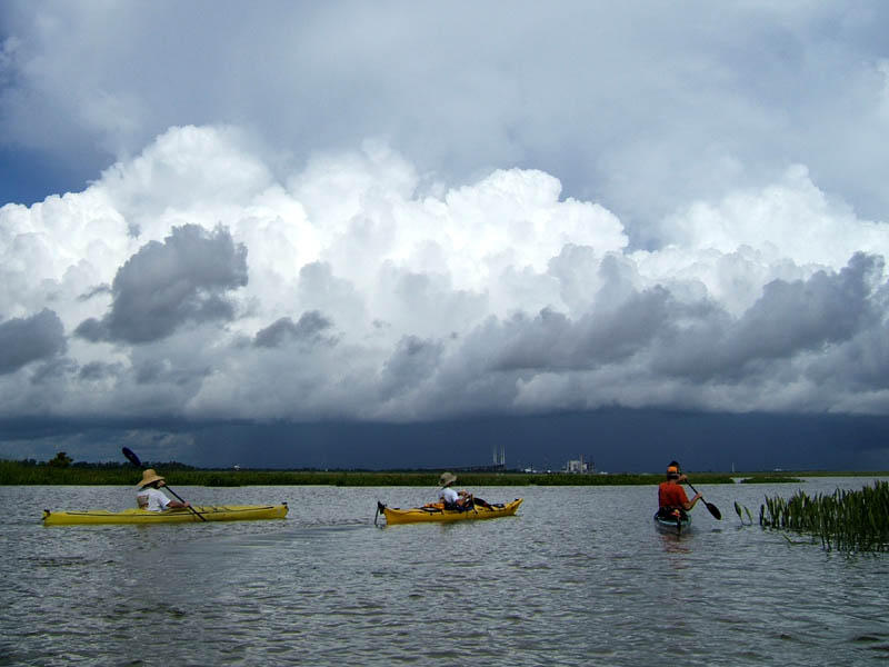
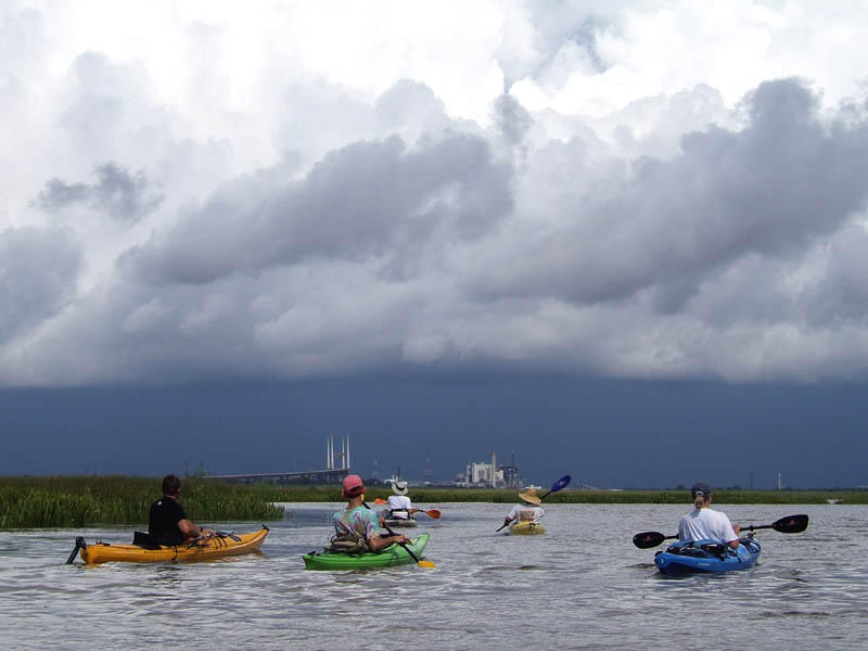
(1) Above left. The original plan was to go kayaking, sailing, and fishing off Dauphin Island. At sunrise, clouds were lighting up and thunder was heard off in the distance south of Dauphin Island. I patiently waited. An hour later, this was the view toward Sand Island. The storm was almost stationary. After some turbulance, the rains started. I waited another hour. Radar showed a big blob of green and yellow on Dauphin Island and it wasn’t moving, lightning was still flashing, thunder rumbling, so I made a change of plans. Rice Creek was the place to be, so I packed up the kayak and moved to the northern creek. (2) Above right. The weather at Rice Creek launch site was beautiful and sunny, although three of the cooler morning hours were now gone. It was hot and sunny the rest of the day.

(3) Above left. There was a green organic film on the surface of the water which gave Rice Creek a swampy atmosphere. (4) Above right. Not far from the launch site, on the south side, the middle tree has wrapped itself all the way around the tree trunk on the right. We’ll never know if this tree hugging is a tender gesture of love, or whether it is choke hold to strangle it’s neighbor.

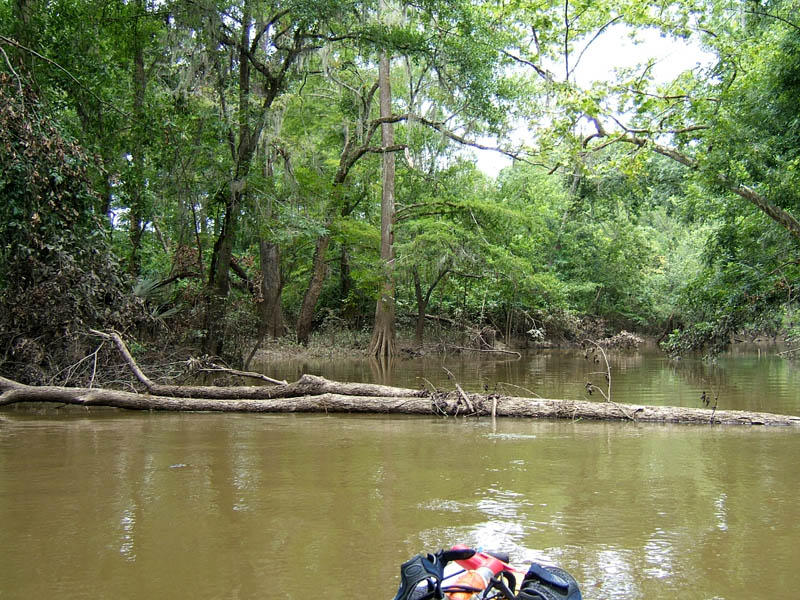
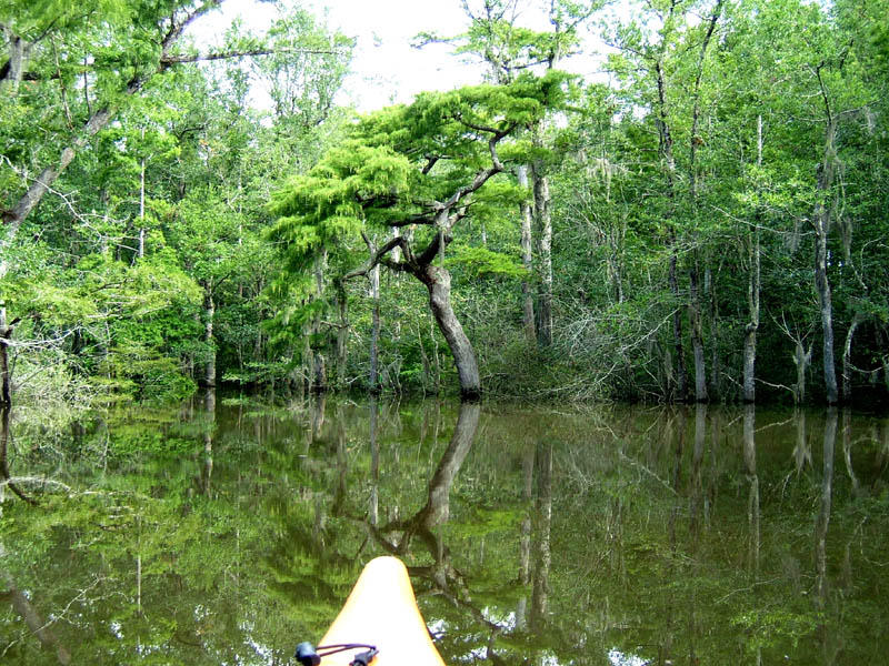
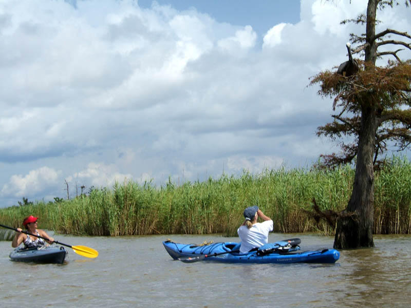
(5) Above left. The new destination for the day was Bayou Tallapoosa, which is a beautiful, narrow winding creek about 3 miles long, that usually has a some current running through it, so it never clogs up with vegetation. After going only about a quarter of a mile, there was a fallen tree blocking the way. If there is one tree down, how many more had the storms blown over? Not feeling up to tree jumping, I chose to turn around. (6) Above right. On the way to Dead Lake, my new destination, there are some nice sized trees.

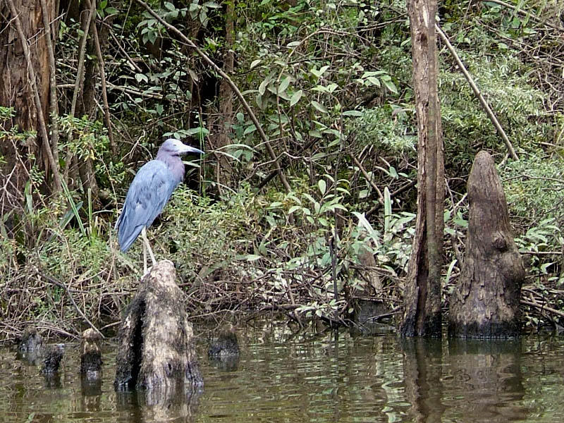
(7) Above left. A little blue heron cautiously watches as I cruise by. (8) Above right. A dead branch caught my attention because with a little imagination, it looked like a camel’s head.

(9) Above left. The Dead Lake Bartram Canoe Trail platforms are about a half a mile northwest of the entrance to Bayou Tallapoosa. These platforms are built solid and the composite surface slats are smooth enough to walk around barefooted on. If you plan to stay on a platform for any length of time, I’d advise bringing a can, or two, of wasp spray. The platform was at a perfect height for me to get in and out of the kayak and had places to tie off several kayaks. (10) Above right. If I’m reading the sign correctly, I was tresspassing when I took this photo because I didn’t have a reservation to stand on this platform. Sorry – I needed to get out to stretch the legs and no one was around.

This subject, though crappy, will hopefully be useful to new kaykers and campers. Each platform has a privacy curtain, but no outhouse. If you are going to camp out on these platforms, what are you going to do if nature calls? The nearby land is swampy and is no place to make a cat hole. I’d suggest reading up on Leave No Trace principles, Click Here or Click Here. It is not healthy to be sending fecal matter in the water around your living area, (our living area), so what can you do? Pack it out with Ziplocks. If you wish to be safer, there are products like Restop 1 and 2, which are sanitary, spill proof, disposable bags that neutralize waste so you can dump your dump in the trash when you get back. There is also such a thing as a kayaker’s Poop tube. For more straight scoop on back country sanitation, Click Here.

Saturday, July 30, 2005

07/30/2005 – Causeway to Little Bateau - Club Trip

Launch: Causeway by the old River Docs. Launch Cost: Free. Route: North into Chocalata Bay to Savage Ditch to Conway Creek to Little Bateau back to Conway Creek, across the Tensaw River, down Lower Crab Creek into Delvan Bay and back. Distance: 15 miles. Average Speed: 3.1 mph. Time: Approx 5 hrs. Pace: Leisurely. Weather: Cloudy morning, then sunny, hot, and humid, slight breeze from the north. Leader: Brint.

(1) Above left. The River Docs launch site on the Causeway. There is nothing at this launch site except red clay so unless you have been there before, it is hard to find. Two ways to help you find this launch site are one, it is 1.5 miles east of the Exxon boat ramps on the north side of the causeway and two, it is just northwest of Ed’s Seafood Shed. (2) Above right. Steve (left) and Brint (right) in Savage Ditch, the narrow cut between Chocalata Bay and Conway Creek.

(3) Above left, left to right. John, Steve, and Danny heading north on Conway Creek. We had a nice cloudy (cool) morning until the sun decided to come out. Then it started getting hot. (4) Above right, left to right. John, Brint, Danny, and Steve heading up the main fork to Little Bateau, our destination for the trip. The main fork turns into three branches giving us three options of how to get into Little Bateau. Brint decided on the right fork.

(5) Above left. Once we entered Little Bateau, it was apparent there were a few American Lotus flowers still in bloom. Steve noted that the big yellow flowers had a scent to them. The American Lotus (aka Pond-Nuts, aka Water Chinquapin, aka Nelumbo lutea) seed pods are often harvested for dried flower arrangements because of their unique size and shape. The seed pod is shaped like a shower head. Both seeds and underground tubers of the American Lotus are edible. (6) Above right. A closer view of the American Lotus flower which is a revered plant around the world with a lot of history that dates back to Egyptian times. Chinese Legend of the Lotus, Egyptian Legends of the Lotus. The Lotus flower garden was so thick that Brint had difficulty finding the way out of Little Bateau.

(7) Above left. After exiting Lower Crab creek into Delvan Bay, we stirred up an alligator in the shallow grasses. This is Danny in his Prijon Kayak and if you carefully at Danny’s reflection in the water, you can see the head of the alligator. (8) Above right. The alligator is more visible as Steve watches it pass by it. Brint, our trip leader, visible in the background, waits for us while we enjoy nature up close and personal.

(9) Above left. After our visit with the alligator, we head south in Delvan Bay toward the bridges. Left to right, Danny, Steve, John, and Brint, still waiting for us. The Battleship can be seen rising over the interstate bridge. Traffic was moving real slow on the interstate due to a wreck. (10) Above right. John is paddling his Wilderness Systems Tarpon 160 Sit-on Top Kayak with the Mobile skyline in the background.

(11) Above left. Danny paddles through the middle of the concrete jungle enjoying the shade. The relief from the sun lasted for about 1.5 miles. Not far from the Exxon boat ramps, Brint pointed out a particular concrete pillar and said that it was his turn around point for his afternoon kayak training trips. Then, without warning, Brint raced off and left his kayak group. He was gone when we got back to the launch site. (12) Above right. Where the three forks out of Little Bateau meet, there used to be a very convenient wooden dock for kayakers to get out on and stretch the legs. Sadly, building, pilings, and dock are all gone. That ticks me off! Kayakers need a solid dock to get out on and stretch the legs – we had one and someone took it away! Kayakers need a place to get out in the Delta north of the Causeway. It is time for me to write a letter. Hope you will take a few minutes to write a letter, too.
James H. Griggs
Gregory M. Lein
Alabama Department of Conservation and Natural Resources (ADCNR)
State Lands Division
64 North Union Street
Montgomery, AL 36130

Tuesday, July 19, 2005

07/19/2005 – Memories - Fowl River

Launch: Memories Fish Camp at the upper end of Fowl River, off Fowl River Road. Launch Cost: $3. Route: Southeast on Fowl River for about 45 minutes and back. Distance: 3.9 miles. Average Speed: 2.9 mph. Time: Approx. 1.5 hrs. Pace: Slow. Weather: Partly cloudy, warm and not too humid. Kayak: Pedal. (Got the parts in to fix the Hobie Kayak so I had to take it out today for a test pedal.)

(1) Above left: Normally a few geese will greet you at Memories Fish Camp on Fowl River. Today, some new ducks were nosing around and the one on the right looked like it was having a bad hair (feather) day. (2) Above right. At the end of today’s trip, the two white ducks were still there. They appeared to be enjoying the full moon.

(3) Above left. There were a few spider lilies in bloom and several nice sized native rhodendron bushes full of white blooms. Also saw some of the old buzzards flying in to roost. Today however, it was the clouds that mesmerized me. There were puffy clouds nearby and in the distance, the plowed field type clouds. To be looking down seeing these clouds and depths of reflections made it feel like I was flying rather than kayaking. (4) Above right. No boats today to ruin the reflections.

(5) Above left. There was a dazzling light show in the sky. The reflection of the sky on the water made it even better. (6) Above right. It was amazing to glide slowly along the water with clouds of fire beneath me (or so it looked). Just when you think you’ve seen some great sunsets, you experience one even better. My eyes and soul are sated again.

“The sky is the daily bread of the eyes.” -Ralph Waldo Emerson

Sunday, July 17, 2005

07/17/2005 – Boathouse Landing to Pine Log Creek

Launch: Boathouse Landing near Fort Mimms on Boatyard Lake. Launch Cost: $4. Route: Southwest on Boatyard Lake about one and a quarter miles, then left (southeast) into Pine Log Creek. Also, up the Alabama River to Holly Creek Landing and into Holly Creek. Area in minor flood stage. Distance: 13.3 miles. Average Speed: 1.9 mph. Time: Approx 7 hrs. Pace: Leisurely to Struggling. Weather: Sunny, hot, and humid. Widely scattered thunderstorms in late afternoon. Kayak: Paddle (as opposed to a Pedal kayak).

(1) Above left. An energetic dog was sad to see me leave without him. In the background is Boathouse Landing which is the next launch site north of French’s Lake. I quit going to French’s Lake because every time I’ve been there, the narrow streams have been clogged with fallen trees making kayaking impossible, and the currents are nasty. The Upper Delta is known for high waters and swift currents in some areas. I didn’t check the river levels before leaving and was surprised to see them about 4 feet or more above normal since we’ve had little rain in the past week. Pine Log Creek, as locals will tell you, can be an eerie place, and today was no exception, although it is much more beautiful when the tide is low. My car is the only one at the launch site, (that alone is eerie) and management advised me the creek was out of the banks from flooding due to Hurricane Dennis (a week later). “Are you sure you want to go out on the water?” Yup. (2) Above right. Here is a photo from later in the afternoon, from the Holly Creek Landing, which is only about a mile northwest from Boathouse Landing. This was a campsite and notice that the water level is close to the roof on the building on the right. You can also see a little bit of current around the tree with the stop sign.

(3) Above left. Deep in Pine Log Creek, there is no creek, just water everywhere. When the water levels are in flood stage, you can kayak almost anywhere in the Delta you want to go. I’ve put two links on the weather category for river conditions. Both SERFC and AHPS indicate the same thing. If Coffeeville, Clairborne, Leroy, or the Barry Steam Plant are in flood stage, you can expect high waters just about anywhere in those vicinities. There are reasons why you might want to know if flood conditions exist in the Upper Delta. Number one: When you can’t see the banks of the creek, which way does it go? I had to backtrack several times today because I lost the path of the Pine Log Creek. It didn’t even look like the one I’d kayaked on in the past. You can easily get lost. Number two: Currents. I fought against 3 to 3.5 mph currents today that were shoving and yanking the kayak in all different directions. It is easy going down river, or across the deep woods, not so easy to go upriver. If you get in the wrong current, you won’t be able go upstream at all. (4) Above right. They grow some big trees in the Upper Delta. It is Sunday and when I pass by huge trees, it feels like I’m on sacred grounds and in the presence of a master Designer of Life.

(5) Above left. The upper woodlands provide some gorgeous scenery where outstretched limbs draped with Spanish Moss serve to capture your attention and lure you to go under them. (6) Above right. You do know to look closely at limbs before you go underneath them, right? This snake’s body was as big around as my ankle and perched at a perfect height to fall right into a canoe or kayak if disturbed. In times of flood, when there is no dry ground, you can bet there will be more snakes in the tree limbs than usual – today was no exception.

(7)(8) Above left and right. It was very enticing to kayak through the deep woods, blazing trails where no one has kayaked before. While kayaking very close to trees, sometimes something would move across the bark and disappear to the back of the tree. These Houdini critters are spiders and some of them get rather big – a leg span of over 3 inches. They can swim and stay under water for 30 minutes, catch fish, and scare the crap out of you if they bolt when you are right next to them when passing a tree. They are master of disguises and will blend in with the bark. These are Brownish Gray fishing spiders. The one with gray must be an old one.

(9) Above left. Holly Creek near Holy Creek Landing – the current became almost impossible to paddle against going upstream. When kayaking in flood conditions, you will generally hear the areas you want to avoid (rushing water). (10) Above right. In contrast to Holly Creek conditions, this is my favorite tree to photograph in Pine Log Creek, where current is almost nil. On this kayak trip, I heard lots of strange noises, including deer and bobcats, something you don’t usually hear in the Lower Delta. I always get on edge when kayaking up in this area. There were sounds of something big slogging through the water in front of me at one time. Could have sworn it was the head of two or three deer in the water, but due to the distance and no binoculars, it was hard to tell.

(11) Above left. This flood displaced millions of critters. While weather forecasters can warn us to head to higher ground, the rest of nature is left to fend for itself. I bet you didn’t even know there was flooding going on a week after Dennis only an hour north of Mobile. In this photo, a nest of ants had to crawl up the stalk of a weed and call it home until waters go down. Somewhere in that mass of ants is the queen. (12) Above right. More displaced critters. Just paddling through this one area was nerve racking because the current kept moving the kayak against these weeds and things I’ve never seen before would drop on the kayak or would be inches from my face and body. So, while I’m trying to knock critters off the kayak with a paddle, my face and body would find the big spider webs crossing between the weeds. Felt something crawling on my bare back and I plucked a spider off. Yes, I paid a price to get these two photos, but it was worth it. In this photo, there are about four different kinds of spiders, two centipedes, some odd bug between the two centipedes, and two cricket type bugs. All the vegetation in this area had similar insect zoos living on them. One thing for sure, the spiders were having a field day with the displaced critters and I could have spent all day here taking photos if it weren’t for all the bugs. Hehehe. Another remarkable adventure.

Saturday, July 16, 2005

07/16/2005 – Causeway to Baygrass - Club Trip

Launch: Causeway by the public boat ramps near the Exxon station. Launch Cost: Free. Route: Northwest across the Tensaw River and Delvan Bay. To the right just after entering Spanish River is Bay Grass Creek, Bay Grass Bay, and a tributary. Distance: 11.5 miles. Average Speed: 2.8 mph. Time: Approx 4 hrs. Pace: Leisurely. Weather: Sunny, hot, humid, slight breeze from the south, with nearby scattered thunderstorms. Tide was high so all the vegetation in Bay Grass Bay was under water, including the yellow flowers. Trip Leader: Brint.

(1) Above left. About 10 kayakers braved the hot, sultry morning to join Brint on his paddle to Bay Grass. Left to right: Roland, Jimmy, Nick, Wendy, Brint, and Francis head northwest across the Tensaw River into Delvan Bay. (Hope I get everyone’s name right – there were a lot of new faces of folks that came over from the Fish River area.) (2) Above right. There are several Osprey Eagle nests along the west side of the entrance of Spanish River. Left to right: Roland (left) takes a break from paddling while Danny (right) checks out the Osprey Eagle flying overhead.

(3) Above left. Francis (left) and Nick (right) are paddling in the heat of the morning up Spanish River. Note the beginning cloud formation of a thunderstorm in the background. On the right in the background is the Cochran Bridge. (4) Above right. Left to right: Brint, Billy, Roland, and Gene in the tandem kayak with someone whose name I can’t remember. Sorry. Notice that the thunderstorm has grown in size, but now we are heading in the opposite direction. Brint apparently looked at an old map and thought the entrance to Bay Grass Creek was on the northwest side. I would have told Brint that he missed his turn, but he was not within shouting distance. We paddled an extra mile or two before he realized something was wrong and stopped. We turned around and went back to the entrance of Bay Grass Creek.

(5) Above left. By the time we went a short distance into Bay Grass Creek and came out into the Bay Grass Bay area, that thunderstorm changed. There was the rumble of thunder in the near distance and a wee bit of tension among the paddlers. Left to right: Billy, Danny, and Brint watch the weather conditions deteriorate just north of Mobile. (6) Above right. Left to right: Roland, Nick, Jimmy, Billy, and Wendy paddle toward the mean looking thunderstorm, probably thinking, “uh oh, we’re going to get soaked, and lightning is not good.” A little rain would have been a welcome relief from the heat.

(7) Above left. We took a turn to the east and left the thunderstorm behind us. Left to right: Jimmy, Brint, and Billy as they paddle up Bay Grass tributary. Pickerel Weed is blooming in the foreground. (8) Above right. Further up in Bay Grass, Fen Roses have just started blooming. Fen Roses, are beautiful perennial herbs, also known as Seashore Mallow, Saltmarsh Mallow, Swamp Pink, Kosteletskya or Kosteletzkya virginica and are closely related to the Hibiscus flowers. I wonder how many kayakers in our group today passed right by these flowers without even seeing them. I remember Fen Roses because several years ago, in August, there was an impressive display of them near Meaher Park that was attracting lots of hummingbirds. http://www.plantatlas.usf.edu/images.asp?plantID=862.

(9) Above left. Brint paddles south in Bay Grass Bay as we head toward Spanish River on the return trip. The new RSA building in the background, under construction, looks suspiciously close to finally being the tallest building in Mobile. (10) Above right. After paddling through the cut from Spanish River into Polecat Bay, Francis watches and Wendy takes a photo of a Pelican sitting in a tree. While we were taking photos, the rest of the kayak group left us behind. Even though I’m a slowpoke, I certainly enjoyed Brint’s paddle to Bay Grass and enjoyed getting to meet some new kayakers. Despite the heat, this was a nice trip.