Showing posts with label Katrina Pass. Show all posts

Sunday, March 20, 2011

03/20/2011 - Dauphin Island Is Back

Launch: Desoto Park (Dauphin Island, AL)
Launch Cost: Free
Destination: Katrina Pass (Now completely closed off)
Distance: 16.2 miles (round trip)
Pedal time: 4 hours
Weather: 65 degrees. Winds out of the south 5-10. On protected side of Dauphin Island, current minimal, tide high at start. Water temp about 65 degrees.
GPS Track: To view or download the GPS track of this trip, Click Here.


Header Image

1) The pile of rocks now spans across Katrina Pass blocking the pass completely. It was only about 6 months ago when they started filling in the pass. Gone are all the oil barriers associated with the BP oil spill. I'm so happy to see the sandy beaches of Dauphin Island back to normal. Dauphin Island is a great place to kayak.

2) Sea Gulls occasionally stalk Pelicans in hopes of getting a free meal.

3) Down by Katrina Pass the shore birds are plentiful and sometimes the birds will let you get remarkably close so you can watch their rituals. Bring binoculars on kayaks trips down here.

4) Two Royal Terns looking at each other with love in their eyes. The mating game is about to commence.

5) Two kayakers coming back from what appeared to be a camping trip to the west end of Dauphin Island. What an absolutely beautiful day to be out kayaking or enjoying the beach.

6) In some of the pools and along the shorelines, like that in the previous photo, the water was teeming with tiny fish.

7) Speaking of fish, two youngsters were in a small boat trying their luck.


8) Out at the west end of Katrina Pass, the fish were biting as quick as you could bait a hook and cast. This little girl hooked something so big it eventually broke her line. Barely visible in the background are the houses on the west end of Dauphin Island.

9) This fellow is reeling in a little one. It was exciting to watch these people reeling in fish after fish.

10) More proof that the fish were biting.

11) While Dauphin Island is beautiful to kayak around again, there were still signs of the BP oil spill. Crews still work the beaches looking for any signs of tar balls or oil. I guess while they wait for tar balls to roll onto shore, they fish. Notice the fishing poles hanging off one of the vehicles? Or, maybe the public can motor down the beach in these battery powered vehicles now...

12) This oil rig sits in salt water, no security to protect it, deteriorating to the point that the ladder is already rusted in half. Wonder what will happen when all the nuts and bolts on the high pressure valves also break after the rust eats through them... I feel sorry for future generations as the decaying oil rigs start falling apart. I also wonder if all the oil rigs near the shore have been constructed to withstand a tsunami wave. After all, the Gulf of Mexico is subject to earthquakes... You did know there was an earthquake just south of Mobile Bay not long ago, right? With oil companies ignorantly manipulating the inner contents of the earth, who knows what is next...

Tuesday, July 20, 2010

07/20/2010 - Loop de Island

Launch: Desoto Park (Dauphin Island, AL)
Launch Cost: Free
Destination: Loop around Dauphin Island via Katrina Pass (which will be soon filled in)
Distance: 22 miles (round trip)
Pedal time: 5-6 hours
Weather: Hot and Humid. Winds out of the east 5-10. 2 foot swells. Distant storms.
GPS Track: To view or download the GPS track of this trip, Click Here.


Header Image


1) Catching a sunrise in order to kayak all the way around Dauphin for my first time, which thanks to Katrina Pass, can be done in half a day. It will take a portage to do this trip in the future after Katrina Pass is filled in.

2) A heavy equipment operator in the process of filling in Katrina Pass.

3) A couple of surfers were riding waves. Mounds of sand have been piled up to protect the Island.

4) The oil spill did not ruin everyone's beach activity. People were fishing off Sand Island.

5) A mother took advantage of the pretty day on the beach of Dauphin Island, south of Audubon Park.

6) Oil spill workers headed out to sea with a well loaded boat.

7) Uh oh, here comes another breaking wave. I got soaked several times today.

8) Getting around the shoal at the southeast end of Sand Island caused some anxiety and is the reason why I've not done this loop before. It might not look bad here, but the steep 3 foot waves were unpredictable and there were breakers involved. I surfed through it for about 3 minutes and hit speeds over 8 mph.

9) An oil worker vehicle scared the birds at the end of Sand Island.

10) Another oil worker vehicle on Dauphin Island.

11) Oil worker vehicle highway on Sand Island.

12) Interestingly, the birds avoided standing on the vehicle paths. Also, I did not see a single pelican on Sand Island which was odd.

13) I was elated to be enjoying the beauty of Sand Island today.

14) To one girl in particular (you know who you are), seeing this reminded me of you. You warm my heart.

15) The oil booms seem to attract birds like these in Billy Goat Hole, near where the Ferry launches.

16) Several egrets.

17) One of these little rooms with a view would be great for viewing sunsets.

18) This great heron is checking to see if it picked up any oil or tar balls during the day - something they are required to do several times a day until all the oil spill is cleaned up.

19) Lovely view for condo owners and renters.

Sunday, July 18, 2010

07/18/2010 - Dauphin Island

Launch: Desoto Park (Dauphin Island, AL)
Launch Cost: Free
Destination: Katrina Pass
Distance: 17-18 miles (round trip)
Pedal time: 4 1/2 hours
Weather: Hot and Humid. Winds out of the south 5-10.
GPS Track: To view or download the GPS track of this trip, Click Here.


Header Image

1) This was my first trip to Dauphin Island since the oil spill. Was worried they might not allow kayaking in the area. No problem launching at Desoto Park. Note the startling new look of the beach on the north side of Dauphin Island.

2) Life goes on during this oil spill crisis - here parents are swimming with their kid near an oil boom.

3) There are several canals on the interior of Dauphin Island to paddle, sheltered from the wind, which seem to be unaffected by the oil fiasco.

4) A front end loader is pulling out a National Guard Humvee stuck in the sand. The natural beach has been replaced with lined units that will absorb any oil that might reach the north side of the island. The units are made by Hesco Bastion and the wall, miles long, extends all the way to Katrina Pass.

5) Tourists - if you are thinking about coming to Dauphin Island to take a walk along the beautiful north beach, you might want to go elsewhere.

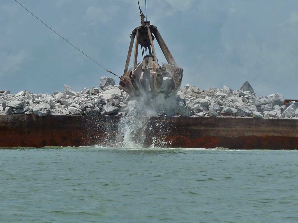
6) Hurricane Katrina washed out 1.5 miles of Dauphin Island in 2005, leaving it split into two pieces. Five years later, Dauphin Island will get it back free of charge, thanks to the kind $15,000,000 donation from BP. Rocks are being off loaded from a barge to a pile on the beach.

7) The rocks on the beach get put on a big dump truck which backs very carefully down a narrow ramp of previously dumped rocks, where it dumps more rocks on the edge of the water.

8) I kayaked about a half mile out into Katrina Pass where another pile of rocks are, looked back and took this photo. Eventually the rock piles will connect together.

9) The pile of rocks offered some protection from the wind and waves.

10) There is some beach area open at the west end of the island where you can land your kayak and get out. Inner island pools are marked with row after row of tire tracks. The dark color is not oil.

11) For the birds, it is business as usual.

12) On the way back to Desoto Park, the smell of petroleum filled the air. Not sure if it was related to boats working the oil spill or whether it came from the Gulf. Either way, it was a nauseating odor.

13) Tar Ball poo or Sea Gull poo? Some people are dealing with nasty booms to help keep the Island free of crude. A big "THANK YOU" to them for all they do.

14) No security at this rig. Anyone in a boat can pull up and do what ever they want. Guess the oil companies save money by not hiring security personnel to protect their sensitive and dangerous infrastructure meaning more profits. Let us not forget that oil wells were the target of terrorists in Kuwait back in 1991.

Saturday, February 10, 2007

02/10/2007 – Dauphin Island

Launch: Public beach just west of Dauphin Island Pier.
Launch Cost: Free.
Route: West along the south side of Dauphin Island to Katrina Pass, and back.
Distance: 12.4 miles round trip.
Average Speed: 2.8 mph.
Time: Approx 4.5 hrs. 
Pace: Slow.
Weather: Sunny, waves were small except around the end of the island where the north winds were kicking up a 2 foot chop, minimal current, rising tide, temperature about 50 degrees, winds from the north 15-20 mph, very low humidity.

1) At DPIA1 early in this morning (I was there for a 5k run), winds were blowing 20-25 mph from the north. Bienville Blvd is still closed at Fort Gains. I can’t get to the jetties launch site so I launched the kayak later in the afternoon at the public beach.

2) This was taken from Katrina Pass. Hurricane Katrina cut Dauphin Island into two. To see before and after satellite images, click here.

3) Early morning photomerge of the rock jetties just south of Fort Gaines.

4) Sunset photomerge taken just west of the pier.

5) Can you believe this is the beach at Dauphin Island? It is beginning to look like Gulf Shores.

6) An American Oystercatcher bird.

7) Inland ponds on Sand Island.

8) A pelican prepares to dive for fish near the Dauphin Island pier.

9) A wonderful sunset on a breezy and chilly evening.

10) Trip Track. Photos 1 and 3 were taken on the east end of the island and are not shown on this trip track image.