Sunday, January 31, 2010

01/31/2010 - Dog River

Launch: Dog River Park

Header Image

1) There was almost two dozen loose tires along a 100 foot stretch of shore. If this is someone's idea of erosion control, that's sad. The tires are nothing but a mosquito farm.

2) Here is a boat ramp next to a drainage ditch that can't be used due to sedimentation. As Dog River fills up with sediment from illegal storm erosion, the river has less capacity to store water. Boats become more limited as to where they can go. Because the river is filled up with sediment, when there is a big rain event, flooding will be worse than it should be. Eventually the river has to be dredged which is a costly task.

3) River trash like this certainly limits water flow and traps more sediment. 

4) It is almost impossible to paddle this river without taking a photo of some wildlife surrounded by trash...how very sad.

5) Dog River isn't all bad. Here is a red maple flower. Note the twig is covered with scale insects.

6) Alabama Marine Police was running a pretty big boat up Dog River.

7) Two brown pelicans had their mouths open. Check out the veins.

8) White pelicans standing in shallow water - another sign of sedimentation.

9) On a brown and grayish day, this colorful shrub growing out of the root ball of a tree laying down, brightened the day.

10) Oddly, a blackbird flew up and chased off this Osprey Eagle.

11) A great blue heron.

12) A duck was talking her partner's ear off. It must have worked because I can't see the ear any more.

Saturday, January 30, 2010

01/30/2010 - Hurricane Bayou

Launch: Hurricane Landing

Header Image

1) After an smooth launch at Hurricane Landing, also known as Perkins Landing, the Mobile Bay Canoe and Kayak Club group paddled up Hurricane Bayou.

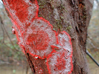
2) This bright Christmas lichen (Cryptothecia rubrocincta) begged to be photographed. It added a little color to this otherwise drab day.

3) At the narrow end of Hurricane Bayou is high enough ground to get out on and take a break.

4) Along the edge of Hurricane Bayou were some small trees or shrubs loaded down with catkins but they also had small cones on the same limbs which seemed odd. There were no leaves on the tree and no one knew the identity. After some research, it appears this tree is in the Birch Family and is called Hazel Alder or technically, Alnus serrulata.

5) We explored some of the backwaters that have beaver dams, but the high water covered the dams.

6) The sun stayed behind clouds and temperatures were in the upper 40s but that didn't stop about a dozen kayakers from enjoying this 6-7 mile trip today.

7) We cut across the gas line canal and went out into the Tensaw River. River current was about 2-3 mph due to recent rains and upstream flooding.

8) It seems like it is always flooding upstream lately causing higher water levels and stronger current in this area. I was paddling down an asphalt road here.

9) Another interesting lichen found blooming so to speak on an old wooden dock. Based on research (always prone to error), I think this is called Jester lichen (Cladonia leporina).

10) Houseboats on Hurricane Bayou. Haven't heard of any Frankenfish horror stories in this area. Frankenfish is a movie filmed nearby in Byrnes Lake back in 2004.

Wednesday, January 27, 2010

01/27/2010 - Pelican Point

Launch: Pelican Point

Header Image

1) Sunrise at the entrance to Week's Bay.

2) There were a bunch of Terns and Gulls standing in the shallow waters this morning.

3) Tide was low. I ended up having to use a paddle for the first few hours today. Waters were too shallow to use the pedal drive. Even half a mile out into the Bay waters were less than a foot deep.

4) Red water (tannic) draining from Bon Secour Wildlife Refuge. I cruised the shoreline of the Wildlife Refuge down to the entrance of Bon Secour River and then followed Fort Morgan peninsula for about 9 miles to the public boat ramp.

5) Typical view of the Bon Secour National Wildlife Refuge. Tree stumps, a little bit of sand and dense grasses.

6) Crossed paths with a pod of about a dozen dolphin that were jumping out of the water and playing with each other. Tall condos on Fort Morgan peninsula can be seen from miles away. I cut across Bon Secour Bay from the boat ramp on Fort Morgan peninsula back to Pelican Point - 10 miles of open water. Winds were variable.

7) A couple of gulls fly past with the moon in the background.

8) Sunset on Bon Secour Bay.

9) Someone on a jet ski likes to take photos of the sunset. Those are birds on the horizon which few out to watch the sunset.

10) A gull cruises by as a heron uses the last bit of light searching for a fish to eat.

Saturday, January 23, 2010

01/23/2010 - Bay Minette Creek

Launch: Buzbees

Header Image

1) 5-Rivers Delta Safari hosted a kayak paddle today. Forecast was for windy small craft advisory conditions and cloudy all day. That is exactly how it was at start time.

2) Pedal kayaks are becoming popular.

3) The group went up into narrow Sibley Creek.

4) A couple of us also went up into Muddy Creek.

5) In the afternoon clouds started to vanish making way for blue skies and warmer temps.

6) The day turned out to be really nice for about a dozen kayakers who participated in this event.

7) Delta Safari plans on hosting about two kayak events a month. Interested in joining a trip but you don't own a kayak? Call in advance for a rental.

8) When the creek has little in way of places to get out, the usual procedure is to connect all the canoes and kayaks together for some great snacking and conversation.

Friday, January 22, 2010

01/22/2010 - Dauphin Island

Launch: Desoto Park (Dauphin Island, AL)

Header Image

1) For the first hour today I pedaled with a pair of dolphin. The dolphin were definitely intrigued with the faster moving Hobie Adventure, sometimes following a few feet away. They turned an ordinary kayak trip into something very memorable. See the video below.

2) The west half of Dauphin Island can be seen in the background. I decided not to kayak through Katrina Pass because the waters were too cold to risk getting capsized in strong current and breaking waves. The number one rule in kayaking says, "When in doubt, don't!" Rather than loop around Dauphin Island, I chose to loop around Little Dauphin Island as a safer route.

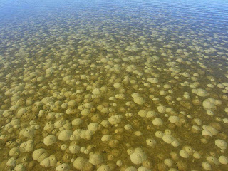
3) Shallow water pool filled with holey mounds.

4) Pink female barnacles?

5) There was a multitude of little sandpiper type birds dotting the sands.

6) The Coast Guard vessel Saginaw is a 160ft Inland Construction Tender in service with the US Coast Guard's 8th District. General duties include search & rescue, harbor security, pollution control, boater safety, and maintaining floating and fixed Aids to Navigation in the Mobile area.

7) The big bridge to Dauphin Island.

8) On the north side of Little Dauphin Island, waters were remarkably clear considering Mobile just had a major rain. Saw a couple of sting rays.

9) Fort Morgan is the land on the horizon. Waters slicked off in the afternoon leaving gentle rolling seas. Around the east side of Dauphin Island, wave size picked up to 2 foot rollers.

10) Back at Desoto Park, two kayak fishermen came in from their fishing trip. One lucky individual will be having fresh fish tonight.