Monday, May 30, 2005

05/30/2005 – Fairhope Yacht Club

Launch: Fairhope Yacht Club (Volanta Street). Route: South to the Grand Hotel, turn around, to Fly Creek, and back. Distance: 13.1 miles. Average Speed: 3.1 mph. Time: Approx 4.5 hrs. Pace: Leisurely to heart thumping sprints. Weather: Predicted thunderstorms. Small Craft Advisory. Winds 20+ mph. I opted for a trip on Mobile Bay since Dauphin Island still doesn’t have a protected launch on the south side. I started this trip knowing I would be soaked by the time it was over.

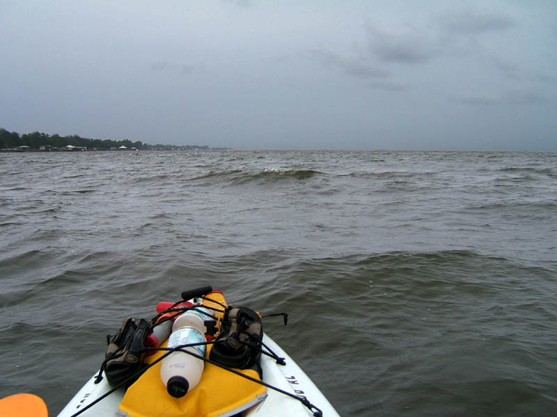
(1) Above left. Started out in fairly calm conditions in the early morning, but the clouds to the south indicated rain was in the near future. Fairhope public pier is in the background, lights still on due to morning darkness. (2) Above right. Usually when there are strong winds predicted from the south, or southwest, the waves can get nice and choppy along the Eastern shore of Mobile Bay – perfect for wave surfing, which is what I wanted to do today. The minute I got to the south side of Fairhope Pier, the winds started picking up and the rains began. It wasn’t long before the whitecaps started forming. Yes, this was good for kayaking, but not good for taking photos. I stayed close to shore because conditions looked much worse further offshore – weather radio was talking 35-50 mph winds in some of the storms. So, why, you ask, am I fool enough to go out in this weather? Good question. Storms never stopped me from going out and playing when I was a kid, so why let storms dampen (pardon the pun) my fun now?

Actually, kayaking is a physical activity, like bicycling (especially if you have a pedal kayak). If you try to ride a bicycle up a steep hill and you are not in shape, you get off and walk – there is no choice – and it is no biggie. You do not see many experienced bicyclists walking up hills though. What about kayaking? At what wind speed does forward progress in the kayak come to a halt? Is it 25 mph, 30 mph, 35 mph, or what? With no forward movement, a rudder is useless and you are left to the will of the waves, wind and current, forced to tack like a sailboat to get to your destination. What kind of waves does it take to cause me concern, cause me to brace, or cause me to turn over? Can I go out and work the wind and waves to get experienced and stronger? Yes. The answers to the important questions concerning wind, waves, and current vary from person to person, vary depending on what kayak is being used, and also vary from location to location. When conditions are appropriate, I like to go out and test my limits while playing.

Conditions off the end of Point Clear were superb for surfing waves. Lots of nice 3 foot waves rolling along at a perfect speed. Trouble was, they were a bit steep and breaking. Feeling like it was only a matter of time before a wave flipped me, I proceed north to more tolerant waves. I rode wave after wave for the next hour until totally exhausted. It was heart thumping fun and the Hobie Outback handled the waves like a champ. The wind suddenly changed directions and the nice formed waves turned into confused seas. The fun was over - time to go inland.

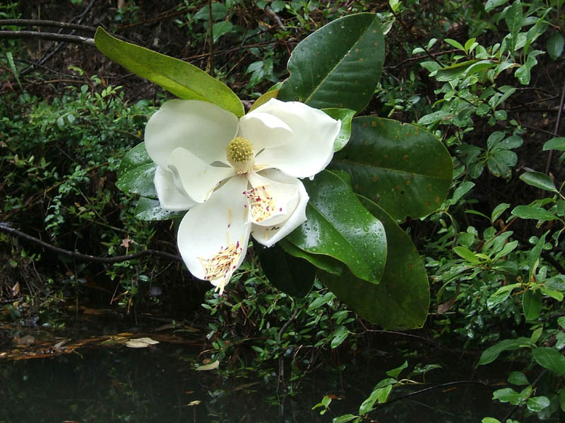
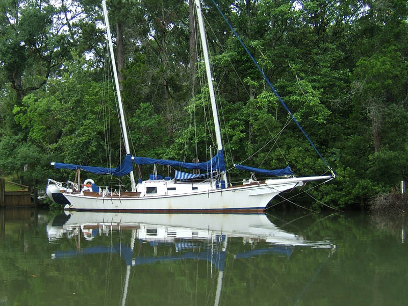
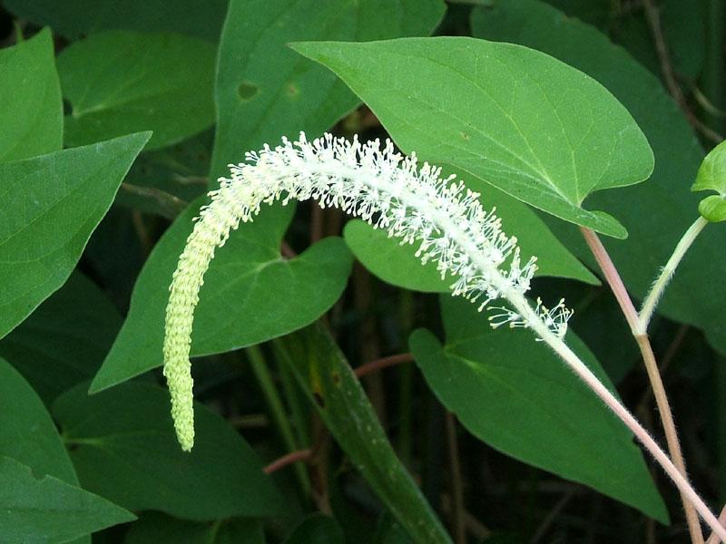
(3) Above left. Went up into Fly Creek into some protected waters where the wind was so still compared to where I had just come from, it was eerie. Saw this sailboat with leaning masts. (4) Above right. Further upstream, there was a downed Magnolia tree putting forth a nice bloom next to the water.

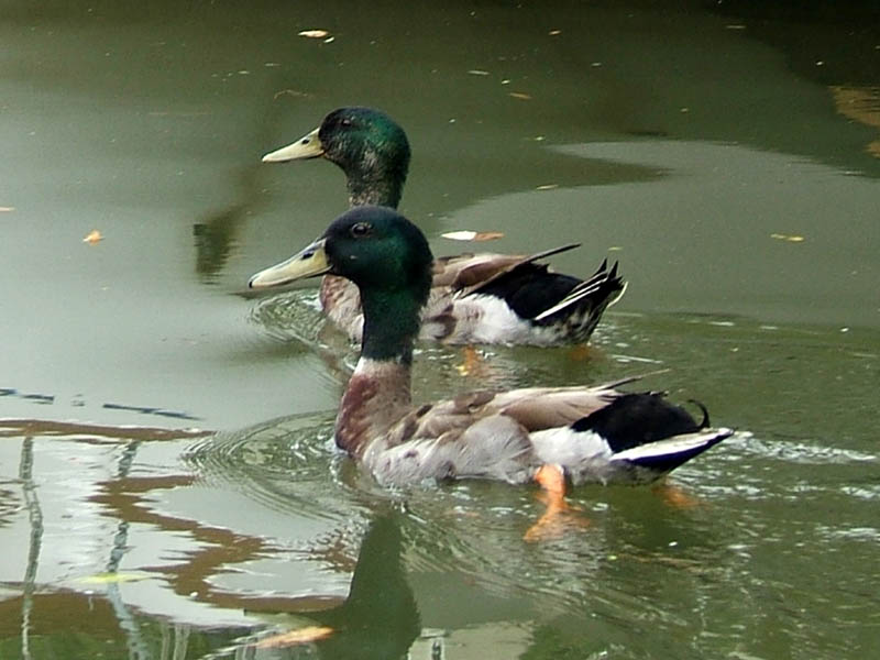
(5) Above left. What is a trip into Fly Creek without seeing the Mighty Ducks. There are seven babies, but not so little any more, sitting on this damaged pier. (6) Above right. Only seconds after taking the photo of the babies, Mighty Ducks (Mom & Pop) came swooping in squawking all kind of obscenities at me to divert attention from their babies. It worked. Today was a good kayaking day. Got a workout and some relaxing time on the still waters, too.

Sunday, May 29, 2005

05/29/2005 – Tucker's to Mobile River

Launch: Tucker’s Lodge (landing) now called Brooks Park. Launch Fee: $1. Route: South on Chickasaw Creek to Mobile River to Choctaw Pass and back. Distance: 20 miles. Average Speed: 3.1 mph. Time: Approx 7 hrs. Pace: Leisurely. Weather: Predicted thunderstorms. Mobile River offers some protection from lighting storms - you can wait out a storm under one of the piers and stay dry. Caution Note: Kayking in lower Mobile River can be very interesting, but it is also a dangerous place. There are tugboats, speeding pleasure boats, bass boats, high security area Naval boats, and even 700 foot cruise ships to contend with. From Chickasaw Creek southward Mobile River has no natural bank to absorb waves. When a boat goes by that is generating a wake, the waves bounce off the piers and go right back into the river. Those waves bounce into other boat wakes creating waves going in different directions. Mix in a fast moving current with strong southerly winds, and the waves can be large, and can come at you from all different directions. Ships are quiet, so you constantly need to look behind you to see if any have pulled out and are creeping up on you. Kayaking in the Mobile River Industrial area is not a place for beginners. Tide was coming in on this trip so there was very little current to contend with.

(1) Above left. Chickasaw Creek. Swallows take a break from their low altitude aerobatics after getting a belly full of insects – hopefully all mosquitoes! The barn swallow is one bird that has benefited from man’s infrastructure. You can often see swallow mud nests underneath bridges. (2) Above right. Have you ever seen a Lean-2 shed? Well, now you have.

(3) Above left. Took this shot while talking to my brother and sisters on the phone. It started clouding up as I approached the Mobile River and the rain started shortly after that, on and off all day long. The orange trucks are Schneider National Carriers parked at the Kimberly Clark facility. In the background is the Africatown-Cochrane Bridge. (4) Above right. Another look at the Africatown-Cochrane Bridge from a kayaker’s perspective.

(5) Above left. This futuristic looking boat called the AMH Seacoaster, was launched at the Austal Mobile Shipyard. The advanced marine vehicle is undergoing testing in conjunction with the Office of Naval Research. http://www.seacoaster.com/ (6) Above right. One of the reasons I wanted to go down Mobile River was to see the RSA building up close. Some of the lower floors are looking completed on the outside. The Mobile skyline viewed from the river will be spectacular when it is finished.

(7) Above left. The sculpture is in Cooper Park, which isn’t even listed as a park according to the official city of mobile website. (8) Above right. I had to kayak to the east side of Mobile River to get this shot. The Carnival Holiday cruise ship terminal is the building on the left. It is much more beautiful from the water than from the interstate. http://www.shipmobile.com/ The Mobile Government Plaza is the building on the right. Our skyline is starting to look real impressive!

(9) Above left. One of the piers along Chickasaw Creek has in interesting shape. The front of the concrete pier is shaped like a ship. It was raining again, but it was one of those nice gentle rains. (10) Above right. This photo was taken while under the bow of a huge ship. I could only imagine what one link of that chain weighs. The ship in the background, Maybank, Helen II, is not a ship, but a warehouse on water. Inside the structure, it is like a well lit warehouse. You can see a Maybank here often because the Mobile Marine Terminal is one of the two main loading ports for this 3 ship company. http://www.maybankshipping.com/eng_vessels.html. This was a most enjoyable day – cloud cover, not much wind, favorable tide, and the thunderstorms stayed away.

Saturday, May 28, 2005

05/28/2005 – Byrnes Lake to McVay, Gravine, and Briar

Launch: Byrnes Lake. Launch Fee: Free. Route: West on Byrnes Lake to Tensaw River, then south to McVay’s Lake. Explore McVay’s Lake. Then up the west side of Gravine Island. Explore the first creek. Then up past the north end of Gravine Island into the cut that goes to Mobile River. Right into Briar Creek. Right into the first creek (un-named) and then back to Byrnes Lake. Distance: 22.1 miles. Average Speed: 2.8 mph. Time: Approx 8 hrs. Pace: Slow. Weather: It was a bit warm - about 90 degrees, chance of afternoon showers that never happened.

(1) Above left. Was on the water about 5:45 am, just in time to enjoy the morning sunrise. Surface fog danced on the water. (2) Never seen so many herons on one trip. The night heron in the above right cropped photo, had just caught a crab, one of their favorite foods. (Sorry, digital cameras tend to blur images in low light conditions.)

(3) Above left. Once into McVay’s Lake, the water’s surface turned into a mirror because there was no boat traffic, nor wind. (4) Above right. Further up into McVay’s Lake, a series of tree trunks with the aid of low tide, made it look like a kaleidoscope. Plus, turn your head sideways so the right side becomes the bottom. Ignoring my sandals, now what do you see? Do you see a head, hair on the head, and the green headband? How about the legs? Whoa, maybe I did too much LSD today.

(5) Above left. McVay’s Lake has about seven forks to explore – one could get lost in there. Unfortunately, alligator weed, water primrose, and some other weed with a single round leaf have banded together and clogged many of the branches. (6) Above right. The birds were very active all along the west side of Gravine Island. I kept passing this tri-colored heron and it would fly ahead landing on a lotus pad, watch me go by, and then fly ahead again. This cycle went on for about 20 minutes. Also saw a flock of white herons, some osprey eagles, and lots of gulls.

(7) Above left. Lizard’s-tail flowers are in full bloom. (aka water-dragon, need-viagara plant, aka Saururus cernuus.) (8) Above right. You can’t forget the lizard’s-tail wildflower because their masses coat the banks of some streams, their flower droops, and their leaves are heart shaped.

(9) Above left. There was a big mass of water willow (aka Justicia americana) in bloom. It is the first time I have ever seen this plant in the delta. It was mixed in with a mass of alligator weed and water primrose. (10) Above right. Upon exiting the Briar creek tributary, a 3-4 foot alligator showed no fear and swam along aside the kayak for several minutes until I was out of his territory. Lots of birds, new flower sightings, friendly alligators, and good exercise. The Mobile-Tensaw River Delta is a special asset to the Mobile area – it is both a natural zoo and a native botanical garden. My compliments to the keepers of the zoo and gardens.

Sunday, May 22, 2005

05/22/2005 – Hurricane Bayou Club Trip

Launch: Hurricane Landing. Launch Fee: $3. Route: Up Hurricane Bayou till kayaks could go no further. On the way back, we went ¼ mile west across the pipeline canal to the Tensaw River. From there, south down the Tensaw, and then back up Hurricane Bayou. Distance: 7.2 miles. Average Speed: Approx 2.8 mph. Time: Approx 2.5 hrs. Pace: Leisurely. Weather: It was a bit warm - about 90 degrees. The shade in the upper end of Hurricane Bayou was a welcome relief from the hot sun.

(1) Above left. I arrived at Hurricane Bayou early thinking I could practice sailing the kayak out on the Tensaw River before the club trip. The rule of thumb that says if no wind, no sail, is true, so I pedaled. The houseboat, located near Cliffs Landing, must have been occupied by a Jeff Gordon fan. (2) Above right. On the way back to Hurricane Landing for the club paddle, the sound of a Wampas Cat, or screeching baby in the woods caused me to stop and say, “What the heck was that!” After searching for several minutes, a movement in a tree helped identify the source of the eerie sound. It was an owl. I’ve heard owls, but never sounding like this one.

(3) Above left. About eight kayakers launched from Hurricane on a hot Sunday afternoon, led by Brint in his Seda racing kayak. There were several new faces in the group. (4) Above right. It was a pretty day to go exploring Hurricane Bayou. It didn’t matter if you had a pedal boat, a sit-on-top, new or old, or a racing kayak – the scenery was enjoyed by all at a leisurely pace. Only two jet skis and one boat passed us during this trip.

(5) Above left. Was it coincidence that we passed by a holey tree on Sunday? Just beyond the holey tree, a family was working to put a roof on a little houseboat. Their kids jumped into the water as we passed by. (6) Above right. Heading south on the very calm Tensaw River, we passed by the homes of the Hurricane Bayou community. Their peaceful location is interrupted by trains crossing a noisy bridge two or three dozen times a day. I could get used to it!

(7) Above left. Not sure how many in our kayak group noticed this tree on our way back to the launch site. It looks like a knee joint, minus the patella bone, and with a hole in it. (8) Above right. Underneath the odd looking tree was a sign. What the heck is a Wompus Cat? Well, there is a band called Cattywompus. In the dictionary of Mountain Talk, Caty Wompus means a vicious beast. Wompus Cat is a sailboat that you can build. Kitty Wompuss is a graphics web site. Wompus Cat is also the name of a Day Lily. Someone must have spelled it incorrectly. I think this sign is more related to the legend of the Wampus Cat. http://www.itasca.k12.tx.us/wclegend.html Kayaking is great fun because if you go slowly enough, there is always something interesting to see. I encourage you to join Mobile Bay Canoe and Kayak Club trips. Visit their web site often for a current schedule of events. http://www.baykayaker.blogspot.com/

Saturday, May 21, 2005

05/21/2005 – Buzbee's Moonlight Club Paddle

Launch: Buzbee’s. Launch Fee: $3. Route: West into Bay Minette Basin, up Yancy Bay till kayakers were slinging up mud, back down Yancy Bay, then across to Blakeley River for a sunset break and then back to Buzbees in the moonlight. Distance: 5.7 miles. Average Speed: Approx 3.0 mph. Time: Approx 2 hrs. Pace: Leisurely. Weather: It was rather warm to begin with, but nice, calm, and sunny. Moon was clearly visible in the daylight.

(1) Above left. About a dozen kayakers participated in the rather warm evening for a moonlight paddle. Since there was no wind, waters were very slick. Off into the glaring sunlight we went. (2) Above right. Further into Bay Minette Basin, waters narrowed. It was us kayakers churning up the slick waters.

(3) Above left. The moon rose before the sun went down. Pete, an Engineer and Surveyor with Driven Engineering, in the orange kayak, was enjoying his first kayak outing with the club. (4) Above right. You may recognize some familiar faces, like Dick and Marilyn, Larry, Brint, and Linda.

(5) Above left. The group, led by Bob Andrews, continued up Yancy Bay until it got too shallow to continue. (6) Above right. We took a break to watch the sunset from the vantage point of Blakeley River before heading back to Buzbees in the moonlight. It was perfect weather for an evening paddle.

05/21/2005 - Dauphin Island to Sand Island

Launch: I drove to the Public Beach and didn’t like the idea of having to launch in crashing waves on the beach. Drove over to the Golf Course and didn’t like the idea of having to tote the kayak and gear so far to get to the beach, so I ended up launching beside the Ferry Dock (Billy Goat Hole). I don’t like that idea because the waters can get pretty nasty when going around the east end of Dauphin Island and you always have to fight current on the return. But, until they fix the end of the road that was wiped out by the hurricanes, there are not many options for easy access sheltered launch sites. Fee: Free. Route: Around the east end of Dauphin Island, then south into Pelican Bay. Distance: 21.5 miles. Average Speed: 2.9 mph. Time: Approx 7.5 hrs. Pace: Leisurely. Weather: Weak cold front had passed through Friday night. Sunny, low humidity, breezy in the early morning, then winds becoming calm.

(1) Above left. I was a bit concerned about going around the east end of the island during max tide flow, but the cold front had pushed the bay water out so the currents were left weak. Soon as I rounded the corner by the rock jetties a shrimp boat came into view. I chased it down and followed behind it for about an hour. There were about 4 dolphins having a feast and they often surfaced right next to me. (2) Above right. Finally, the shrimp boat captain cut the throttle on the big diesel engines and the crew began hauling in the nets. This act sent the birds into a frenzy. If you get in close to the action, make sure you wear a rain coat due to the big drops of white rain. Birds were diving into the water as close as 3 feet to the kayak.

(3) Above left. After the Bubba Gump excitement, I hoisted the sail and proceeded to practice sailing in relatively calm winds of 5-10 mph. Sailing adds a little more FUN to the activity of kayaking. If the wind dies down, the Outback can be paddled, or pedaled. (4) Above right. I’m a firm believer in visibility when around boating areas. You can always recognize me by the ORANGE flag seen on the kayak, as it sits on the beach in the northwest corner of Sand Island. Over the past year, Sand Island is slowly moving closer and closer to the pier. If you look closely, you can see waves breaking under the pier. Navigating on the outside of the fishing pier is going to be real dangerous for kayakers – and boaters. As Sand Island encroaches toward Dauphin Island, the water passing between the two islands flows faster. The appeal of Sand Island as a kayaking destination is strong, but let me emphasize again, the area by the Pier and south of the Public beaches can be treacherous.

(5) Above left. Black Skimmers are unusual birds. Their beaks look huge from a side view, but if you look at one straight on, you cannot see the razor thin beaks. They get food by flying along the surface of the water with their longer lower beak in the water scooping up fish sticks. If you spend a few minutes observing Skimmers, you’ll also notice that some of the birds in the flocks appear to be dead. There are two in this photo sprawled out on the sand. I don’t know why they lay down on the sand in such manner that it makes them look dead. Strange bird – you can’t even tell it has eyes. (6) Above right. The Dolphin seem attracted to the Hobie Outback. This group here is giving their nod of approval for the pedal boat that operates by FLIPPERS. At least a quarter of my time today was spent cruising with the Dolphin club.

(7) Above left. As I’m cruising along the north side of Sand Island, there was an area of turbulence in the water with no visible cause. Nearby, the water surface showed signs of current, but again, no reason why. In the midst of this was foamy water. As I passed through the foamy water, schools of what appeared to be catfish were on the surface of the water eating or breathing. They were almost within touch before going under. Hard to see the fish in the middle of this photo, but with polarized lenses, I was seeing them more distinctly. Also saw horseshoe crabs and stingrays. (8) Above right. Every time this fisherman cast his lure out into the water, his silly dog starting jumping up and down in the water and then swam after it. One time as the man brought in the lure, it had a 15 inch skipjack on the end of it, which of course, the dog had to inspect. Sand Island in the background.

(9) Above left. On the way back from Sand Island to Dauphin Island, the winds stopped and the seas slicked off. What a gorgeous day. The land on the left is the East end of Dauphin Island. This photo of the pelican was snapped about 1.5 miles off shore. (10) Above right. As I pulled up to the beach, four other kayakers in sit-on-top paddle kayaks were doing the same. They were young high school or college kids – two guys, two girls and they looked tired. One guy says, “How long did we rent those kayaks for?” Someone answers, “Four hours.” All but one girl got out of their kayaks, dragging butt. She slumped down and proceeded to soak up the sun. Someone says, “Well, what are we going to for the next three hours?” One hour in a kayak wore them out. There it was, slick water, beautiful kayaking conditions, and the rented kayaks sat there empty, except for the one being used by the sunbather. We all have different priorities…