Showing posts with label Cows. Show all posts

Friday, May 18, 2012

05/18/2012 - ASRT Black Warrior Nature Paddle

Launch: On the Black Warrior River northeast of Demopolis at Old Lock 5 Park. Launch choices were a Rock bank, a concrete boat ramp, or a fixed concrete dock. It would have been nice to have a kayak designated launch area - friendly grass or sand bank to launch from. I struggled and ended up hurting my wrist while getting out on the high concrete dock as the one lane boat ramp was busy.
Launch Cost: Free
Destination: Explore Big Prairie Creek and a couple nearby sloughs.
Paddle Distance: About 20 miles (round trip)
Paddle time: 7.5 Hrs
Weather: Sunny, winds calm to 5 mph. Air temp 75-85 degrees. River and Creek currents minimal at less than 0.5 mph.
GPS Track: To view or download the GPS track of this trip, Click Here.

I went up to Demopolis early for the Alabama Scenic River Trail's Black Warrior Nature Paddle event and got in a paddle before the group gathered in the evening at Foscue Creek Park.

A few areas along Big Prairie Creek were swamped by wild Coneflowers (Dracopis amplexicaulis).

Mayflies were dense along the shoreline.

A male Widow Skimmer (Libellula luctuosa) dragonfly.

Yes, they have Alligators in Big Prairie Creek.

This turtle's shell had a thick layer of algae on it.

Pearly Crescentspot butterflies were abundant.

Pearly crescentspot on a coneflower.

The major theme of the ASRT Black Warrior Nature Paddle was birds. Here is an Osprey Eagle.

A pretty blue bird.

A turtle shares his log with a turquoise eye colored Cormorant.

The Cormorant flew off and dove into the water.

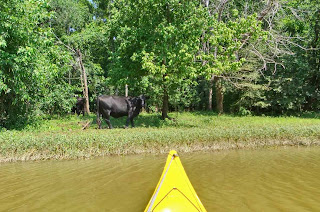
While cows are not wild animals, to see such huge animals next to the shoreline on a paddle does make the paddle more interesting.

There was small section of Big Prairie Creek where the water color became a funky green color. When I mentioned this to some local Demopolis residents, they brought up the subject of sewage pollution from Uniontown. Uniontown is 12 miles away though and sewage spills release into Cotton Creek, not directly into Big Prairie Creek and this green colored section was confined to about a mile stretch of Big Prairie Creek. There is nearby farmland so perhaps this was an algae bloom related to fertilizer runoff. There are also about a thousand catfish farm ponds to the east of this creek. Most of the creek color was light brown like in photo 11.

Big Prairie Creek is a beautiful creek to paddle with almost no sign of civilization. The creek is long enough that you can paddle all day in it without running into a dead end or a log jam.

There are at least nine beautiful sloughs within 2 miles of the Old Lock 5 Park of which I only had time to explore three of them. Motor boat traffic is rare in the sloughs while wildlife and bird watching opportunity is maximum.

Osprey Eagle.

Friday, July 08, 2011

07/08/2011 - Choctaw NWR

Launch: Lenoir Landing Park just north of the Choctaw National Wildlife Refuge in Choctaw County, Alabama.
Launch Cost: Free.
Destination: Exploratory paddle of the upper portion of Choctaw NWR including Okatuppa Creek. There is plenty of paddling territory up here!
Distance: 26 miles (round trip)
Paddle time: 8-1/2 hours
Weather: Another hot day in Alabama. Mostly Sunny. Rising tide. Minimal (<0.5 mph) current. No waves. No wind.
Caution: If you are exploring, beware, there is a Submerged Dam (Coffeeville Dam) 9 miles south of the launch site on the Tombigbee River.
GPS Track: To view or download the GPS track of this trip, Click Here.


Header image shows a bunch of water hyacinth plants in bloom.

1) Sunrise on the Tombigbee River which is only about a tenth of a mile wide here.

2) There are many little sloughs to explore off Okatuppa Creek, including Judys Slough. The scenery was beautiful. The entrance to Okatuppa Creek and the upper Choctaw NWR area is about 3 miles south (an hours paddle) of the Lenoir Launch site on the Tombigbee. It is half that distance if you launch at the Choctaw NWR landing.

3) There were some Lotus flowers in bloom.

4) The seed pod of the Lotus flower.

5) I paddled up Okatuppa Creek until it got shallow near this farm where I spooked a herd of cows.

6) Saw plenty of Atlantic Pigeonwing flowers in the woods (Clitoria mariana).

7) Saw more green herons today than anything else.

8) Just when I thought it would be a dead end due to dense vegetation, there would be a little inlet leading to more spectacular views. I love exploring new waterways. Bet this area would be great to paddle during fall foliage.

9) This was a very heartwarming paddle today. The red objects are mosquito ferns.
The heart objects go to that special woman out there. You know who you are.

10) There were so many waterways to explore and not enough time in the day. I'll have to finish going up this shady in the middle of the day slough which is across the river from Choctaw NWR another day. There is still the Tallawampa Creek and Turkey Creek areas to explore, too.

Saturday, January 31, 2009

01/31/2009 – Gunnison Creek Club Paddle

Launch: Steele Creek Park in Satsuma, AL
Cost: Free.
Distance: Approx 6 miles
Route: Up Gunnison Creek to just past Interstate 65 and back.
Pace: Leisurely.
Average Speed: 2.7 mph.
Weather: Sunny, 55-60 degrees, calm conditions.

Today I led a kayak club paddle up Gunnison Creek and had the pleasure of padding with Ryan, her mom Randi, and Kristen, all three from Bay Minette, and Tom, and John. Hope I’m spelling names right.

1) Kristen and Ryan take the lead up Gunnison Creek in ideal kayaking conditions.

2) John and Tom look at a small paddle wheel boat.

3) Everyone was enjoying a pleasant deep blue sky day.

4) It didn’t look like there were very many homes on this creek based on looking at Google. Must have been an old image – there were a lot of homes along Gunnison Creek.

5) Randi looks at another paddle wheel boat – we saw 3 on this trip.

6) Kristen eyes the creek banks for wildlife which we didn’t see much of except for a few turtles. The water had a slight green tint to it and I was surprised how clear it was. We also noticed that there were Red Maples starting to put out color.

7) The cow on the creek bank seemed a little startled as it watched all the colorful kayaks going by. (click on the photo for a larger view – the cow is on the bank just above Randi’s front hatch). I couldn’t tell if the cow was watching only the red kayaks or not.

8) Not far after crossing under I-65 we stopped for a short break at our turn around point. These timbers are remains of the old bridge crossing for old US Highway 43. I was thinking this might be a great place for launching a kayak but it is private property according to Probate Court records. On the other side of the creek is a swimming hole diving platform about 20-30 feet in the air.

9) A couple of shortcuts were taken on the way back. Gunnison Creek has a several splits in it, some leading quickly to dead ends, others merely loops.

10) All good things must come to an end. If you look at this photo carefully, the one thing I didn’t anticipate was for the water to be so low. It was a long drop from the dock to the water surface today as compared to other times meaning everyone had to use the concrete boat ramp to launch.

Thankfully no one went swimming today. Rising air temperatures can promote kayaking in t-shirts or other light clothing. It is important though, to remember the water temperature doesn’t change rapidly like air temperature. A boater drowned in the Tensaw River today. Be careful out there!