Saturday, July 30, 2011

07/30/2011 - Bayou Zeast

Launch: Mobile County River Delta (formerly Dead Lake Marina). Exit 22 on I-65, then follow the signs for 4 miles. The Mobile County River Delta and Welcome Center is currently undergoing a massive 1.6 million dollar improvement project so watch out for construction.
Launch Cost: $3.00 (Office opens at 6:00 am and closes at 4:00 pm.) Outside of those hours, go the the guard shack. Must have boat launch pass displayed in vehicle.
Destination: Explore Bayou Zeast. There are no public launches nearby so it requires a 9 mile paddle just to get to it.
Trip Rating: Difficult. Long distance. Open waters. Potential for strong current and large waves.
Distance: 30 miles (round trip).
Paddle time: 10 hours at a leisurely pace.
Weather: Fog in the morning, then mostly sunny. High about 90, very little wind. Tiding coming in. Current about 1/2 mph or less.
GPS Track: To view or download the GPS track of this trip, Click Here.


Header image is a photomerge showing the Dolly Parton bridge. A work crew is putting together a replacement bridge for a railroad trestle about 7 miles downstream.

1) Conditions at the start of this morning's paddle - hot, armpit drenching humidity, and steamy hot. Glasses kept fogging up.

2) A foggy sunrise. It didn't take long for the fog to burn off.

3) Mobile River had minimal current and almost no wind. The I-65 bridge can be seen over the trees on the horizon.

4) The I-65 bridge over Mobile River is widely known as the Dolly Parton Bridge. Its true name which most people don't know is the General W.K. Wilson Jr. Bridge. The entrance to Bayou Zeast is about 1-1/4 miles north of this bridge on the right hand side (east side).

5) Bayou Zeast is wide to begin with and it seems to go on forever.

6) Further upstream Bayou Zeast begins to narrow.

7) Almost all the area along Bayou Zeast is a low elevation fresh water cypress swamp. Had the water been 3 foot higher, it would have been possible to paddle just about anywhere.


8) There are a couple dozen trees of respectable size in upper Bayou Zeast.

9) It is unbelievably quiet in Bayou Zeast - almost no boats today. It is a rather odd feeling when you paddle by a tree and something goes scurrying up the tree sounding like a squirrel. Instead of seeing a squirrel, you look up only to see a spider with 4 inch legs staring at you from about eye level.

10) It is a tree frog (pun intended).

Thursday, July 28, 2011

07/28/2011 - Dog River Sunrise Pedal

Header Image is a photo of the sunrise on Dog River.

1) Pre-sunrise.

2) Clouds to the west lit up by the rising sun.

3) To the east, not looking good.

4) Back to the west, a rainbow.

5) A line of clouds went by and the winds went from calm to blowing hard.

 6) It is raining by the trees on the horizon - time to get out the umbrella.

7) Little storms were popping up all over.

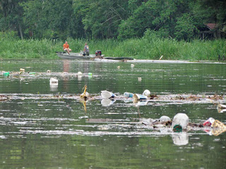
8) Later on when the rains stopped, a heron was seen scrounging through the trash for food.

9) A cluster of fruits on a Sweet Bay tree (Magnolia virginiana).

10) The horses were having grass for breakfast.

Tuesday, July 26, 2011

07/26/2011 - Upper Dog River & Moore Creek

Header image. Styrofoam is noted for breaking up into pieces that choke animals and clog their digestive systems. Many cities and counties have outlawed styrofoam. Alabama is a little behind when it comes to caring for the environment. Styrofoam contains the toxic substances Styrene and Benzene, suspected carcinogens and neurotoxins that are hazardous to humans.

1) Went out this morning paddling Dog River and found a wild Crepe Myrtle shrub growing in the water of Moore Creek.

2) A young heron.

3) MAWSS workers were removing pipe from Eslava Creek ending a four month long sewer cleaning project. Bolton Branch and Eslava Creek are not blocked by a sewer pipe anymore.

4) The MAWSS sewer pipe trapped some of the trash.

5) A tree that fell into the water recently acted as a trash trap.

6) Further upstream in Eslava Creek where water levels get higher, tree limbs act as a trash trap, but rather than collect plastic bottles and styrofoam, limbs collect plastic bags.

Monday, July 25, 2011

07/25/2011 - Dog River Scenic Blueway Woes

Header Image. YUCK!

1) Thought I'd go out kayaking in an afternoon thunderstorm. An umbrella kept me dry except for the bottom of the legs which was fine with me in the heat of summer.

2) I kayaked upstream to the Dog River Park area and this is what the Dog River Scenic Blueway looks like after a heavy rain. This is unacceptable.  Something needs to be done to stop the flow of trash from Mobile's streets into local waterways.

4) Leave a comment if you have an opinion.

5) Leave a comment if you have an opinion.


6) For another perspective on Mobile's illegal river trash dump, watch this short two minute video. This trash originated from upper Dog River (Eslava Creek, Bolton Branch).

Sunday, July 24, 2011

07/24/2011 - Fish River

South Alabama Paddlers club trip: Nancy led a club paddle today on upper Fish River. The skies were threatening with rain and distant thunder. We were the only two to brave the heat and storms. The heat was lowered by the nearby storms and cloud cover. It never did rain on us making this a very pleasant trip. Thanks Nancy!
Launch: Big Daddy's Restaurant is on the west side of Fish River about 8 miles west of Point Clear, AL.
Although the boat ramp sign says, "Launch Closed," it is my understanding that it is okay for kayakers to launch there. A good way to say thank you to the owner for the privilege would be to eat at Big Daddy's when you get back from your kayak trip. There is live music in the evening on the weekends. After our trip, we replenished the spent calories while listening to live music.
Launch Cost: Free
Destination: Upper Fish River where there is a "No Wake Zone" north of Highway 32 and not many boats. Lower Fish River gets very busy with boat traffic.
Distance: 5 miles (round trip)
Paddle time: 2 hours at a leisurely pace.
Weather: Cloud cover kept the temperature in the 80s. Winds were light. Tide was going out and current was negligible.
GPS Track: To view or download the GPS track of this trip, Click Here.


Header Image is a scene typical of upper Fish River - lots of turtles.

1) Big Daddy's launch is in a small cove off Fish River. Once out on Fish River, the shoreline is populated by many houses. North of Hwy 32 the river houses become less dense.

2) Nancy led us through an isolated shortcut where we saw a brilliant red cardinal flower in bloom (Lobelia cardinalis). Cardinal flowers have been put on a "threatened" status in neighboring Florida.

3) There were a few boats that passed us and most were considerate by slowing down.

4) "Drat!" The turtle skedaddled off the log before auto focus could do its thing.

5) Fish River was bustling with activity on the clean waterway. Some shallow areas became noisy party areas for older kids.

6) Several home docks were swarming with young kids having a blast. Surprisingly, the water in Fish River is quite cool compared to waters in Mobile Bay or the Delta.

7) Nancy shows us what a loose paddle grip looks like which is a good thing because you are less likely to suffer wrist strains if you paddle with a loose grip.

8) This is the kayak launch site at Big Daddys. The rains held off until we were in the restaurant. Thumbs up on paddling upper Fish River. The "LAUNCH CLOSED" sign is only for motor boats.

Saturday, July 23, 2011

07/23/2011 - Mobile River & Three Mile Creek

Header Image is a photo merge of Spanish River just before sunrise.

1) A slight hint of dawn is seen in the sky after launching at Shirleys in the dark.

2) Sunrise in the Bay Grass area was jaw dropping. 

3) A perspective of how I get a photo of the sunrise.

4) An osprey eagle nest on Spanish River had two occupants.

5) Over a dozen white ibis were hanging out on a tree along Mobile River.

6) The CSX railroad track is close to Mobile River.

7) A roll cloud passed by overhead near the entrance to Chickasaw Creek. It briefly generated some wind which sure felt good on a hot humid windless morning.

8) A juvenile heron.

9) I kayaked to the shoreline several times to take photos in Three Mile Creek. As the kayak bumped into vegetation, it rained ants all over me and the kayak. The underside of this coco yam leaf shows why - it is covered with ants feeding off aphid nectar. Coco yam is an invasive foreign species from Africa called Elephant's Ear or wild taro (Colocasia esculenta). Pigweed was another species of plant that the ants took over.

10) The invasive Apple Snail eggs can still be seen in Three Mile Creek.

11) The flower shown here is one I've never seen before. Anyone know what it is? (Update: The wildflower is a Turks Cap or Wax Mallow (Malvaviscus drummondii (some classify it as a sub-species: Malvaviscus arboreus var drummondii).)

12) A green heron looking for food.

13) Symptom of our disposable society and Mobile's tolerance of roadside trash.

14) There are some big ships in Mobile River.

15) Despite boats being in the vicinity, no one came to help these boaters whose engine had broke. The painfully slow trek back to their boat launch using a trolling motor was aided by wind power. One guy said they even got on the radio and asked for help. So, you think if you have a problem while kayaking that people will instantly come to your rescue if you holler for help? You might want to rethink your rescue strategies so you have a backup plan "B". What if you break an arm or injure your shoulder and you can't paddle? Based on what these guys did, investing in a WindPaddle might be a good idea.