Wednesday, December 31, 2008

12/31/2008 – Last Sunset of the Year Club Paddle

Launch: Fairhope Yacht Club
Kayak: Hobie Outback
Route: Club paddle lead by Gene - no route – just paddle out into Mobile Bay to experience the last sunset of the year from the kayak.
Pace: Leisurely to drifting.
Weather: Sunny, 55 degrees, bay waters with a small chop. Conditions were calmer than forecast.

1) Every now and then a few 1-2 foot waves would come rolling in keeping everyone on their guard for small breakers.

2) Six kayakers braved the cool conditions to celebrate the end 2008.

3) There was a cool wind gently blowing into our faces while we watch the evening’s light show. It felt good.

4) It was a pleasure to see the last day of the year colorized.

5) The last hues of sunlight and the year 2008 fade into the past. I shan’t mention who the kayakers are in these photos because that was not common bay water in those glasses. Cheers!

6) There was a cool wind gently blowing into our faces while we watch the evening’s light show. It felt good.

Tuesday, December 30, 2008

12/30/2008 – Pumphouse Canal

Launch: William Brooks Park (Hwy 43 in Chickasaw)
Launch Fee: *Free (Normally $4)
Kayak: Necky Looksha Sport
Route: East in the Pumphouse Canal, southwest down Bear Creek and Greenwood Bayou to Chickasaw Creek, then to Cochran Bridge and back via Chickasaw Creek.
Distance: 13.9 miles.
Average Speed: 2.5 mph.
Pace: Leisurely to still.
Weather: Sunny, 65 degrees dipping down to 55 degrees after sunset, waters mostly calm.

1) A 3 foot alligator warming up in the sun.

2) The Pumphouse Canal – a man made canal that is about as wide as you see here that connects the Chickasaw Creek to the Mobile River.

3) Please note: the Pumphouse Canal is subject to being blocked by a log jam at the railroad trestle near Mobile River. I had planned to kayak up to Black Creek today but this 100 yard long log jam caused a change in route.

4) Instead, I went down Bear Creek and Greenwood Bayou – an area that always seems dead of life. It is even worse at low tide when you can smell the exposed mud banks.

 5) About the only thing I see in this area are Osprey Eagles – who build their nests on top of the high voltage transmission lines that cross the Delta in this area. 

6) On the way back, I noticed a 22 degree halo around the sun – not something one sees very often.

7) The railroad bridge crossing Chickasaw Creek at the entrance to Mobile River looks like it is sustaining some rust damage. In this photo, there are 4 cross bar members completely destroyed by rust. The bridge operator who I talked to said the bridge was in good shape. Guess he doesn’t see it from a kayaker’s perspective.

8) The designer of the sky put on a long and awesome performance that lasted for 40 minutes. The photo merges are wide photos - you might have to scroll to see all of the photo. This sunset was watched in the area where Chickasaw Creek joins Black Bayou.

9) The bad part about wanting to take photos of a sunset on the slick evening waters is boats wanting to return at the same time that stir up the calm waters. But, sometimes boat wakes can create some interesting photos amid all the colors.

10) Sunset on Black Bayou

11) Wow! I’ve missed kayaking. It is the simple pleasures in life that can make you shout loudly in joy deep within. Thank you Steven Sasson! Steven developed the first digital camera in 1975.

12) Sunset on Black Bayou

Monday, December 29, 2008

12/29/2008 – Chickasaw Creek

Launch: William Brooks Park (Hwy 43 in Chickasaw)
Launch Fee: *Free (Normally $4)
Kayak: Hobie Mirage Outback
Route: South down Chickasaw Creek to the entrance of Mobile River and back.
Distance: 11.3 miles.
Average Speed: 3.3 mph.
Pace: Leisurely to Moderate.
Weather: Sunny, 65 degrees, winds 5 mph from the north, waters mostly calm, stronger current out in Mobile River. Water temperatures are also 5 degrees cooler in Mobile River.

1) Currently, this site is not monitored by anyone. There was a locked moneybox for the voluntary launch fee of $4, but it had been vandalized. Today I kayaked for *free. Eventually there will be a restroom, office building, and concession stand at this facility.

2) Today’s launch was at William Brooks Park, formerly Tuckers Launch. On the design drawing, one of the three launch sites is designated for “Canoe.”

3) Near the entrance to Mobile River, I took a photo of Scott Paper Company with the sun hiding behind the big smoke stack. Jet contrails like those in this photo, are linked to global dimming and temperature attenuation. They say if the jets all stop flying for some reason, this planet will get hotter very quick.

4) Two trains went by as I was pedaling in this area. Some of the graffiti on the cars were pretty cool looking.

5) If you paddle Chickasaw Creek often enough, you’ll see the Crimson Shipping floating warehouses. The company was formerly known as Maybank.

6) A pelican feeding with the Cochran Bridge in the background.

7) I like to time kayak trips to coincide with either a sunrise or a sunset. I was hoping the jet contrails would add color to the sunset but almost all of it disappeared before the sun went down.

8) Do you think Osprey Eagles and other birds enjoy watching the sunset? This one sure looks like it enjoyed the sunset as much as I did!

Sunday, December 28, 2008

12/28/2008 – Buzbee's

Launch: Buzbees in Spanish Fort
Fee: $3.
Route: West to Blakeley River via Yancy Bay Cut, then back up into Bay Minette Creek into Muddy Branch.
Distance: 7.6 miles.
Average Moving Speed: 3.3 mph.
Exploring time: 3.5 Hours.
Pace: Leisurely to idle.
Weather: Cloudy to Sunny, 60-70 degrees, calm winds, water approx 60 degrees.

1) Bay Minette Creek Bridge and the Necky Looksha Sport kayak that I was testing.

2) It was a dreary looking day. Weather radar showed a line of showers in the county north of us. Figured I try out the kayak for 30 minutes or so before it stormed.

3) After about an hour on the water, the clouds melted away and the sun began to shine.

4) Winds abated to less than 5 mph and the waters slicked off. What a great paddling day this turned out to be.

5) Not long after I put on a layer of sunscreen, a voice called out from behind me. Tom, relatively new to kayaking, saw me from afar and came over to visit in his sharp looking Solstice GT kayak. 

6) We chatted for a time and then paddled back to Buzbees. Tom landed at Buzbees and I proceeded up Bay Minette Creek.

7) Bay Minette Creek was one of my favorite places to paddle because it was so untouched by modern development. There are almost no houses, docks or boat ramps to be seen along this creek. Unfortunately, the above left photo is the look of the future. More boat docks protruding into the creek and more power boats noising up the environment.

8) An old branch sticking out into the water took on the characteristics of a marine animal crying out, "Please, no more power boats!"

Saturday, December 27, 2008

12/27/2008 – Hobie Mirage Outback #2

Launch: 5-Rivers off the Causeway (Highway 90).
Launch Cost: Free.
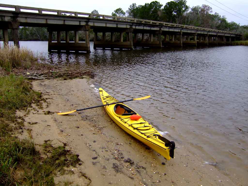
Route: Back and forth on Sardine Pass to test and set up a new kayak.
Distance: 1.5 miles.
Average Speed: 2.0 mph.
Time: Approx 45 minutes.
Pace: Stop & Go.
Weather: Mostly cloudy, 72 degrees,
SSE winds 15 mph, water temperature approx 62 degrees.

1) Winds were light in the protected areas of Sardine Pass where I was setting up my Christmas present – a new kayak. At the same time, a mother and her son were testing out a Hobie Mirage Tandem kayak. Several others kayakers were taking advantage of the nice 70+ degree weather.

2) The 5-Rivers facility can be seen in the background.

Having been without a kayak for the past year and a half, I finally took the plunge (no pun intended) to help the sagging economy and bought my second Hobie Mirage Outback pedal kayak. My first Outback was retired about 2 years ago after taking 5 years to wear it out. Hobie has been listening to owner feedback and has implemented many recent design improvements. The main improvement I was waiting for was a stronger pedal drive unit and that came out this year. So I’m supporting Hobie’s endeavors to improve their pedal kayak even more by getting another one. Hopefully these new pedal drive units will be much more reliable than the older ones. Hobie supports their kayaks 100%. If I get 5 years worth of enjoyment from this new Outback like I did the last one, you can't put a price on enjoyment and bliss.

For those of you who used to visit this blog to see new photos, the old format will continue - this is a photo journal of kayaking trips in the Mobile-Tensaw River Delta. Posts are open for public comment, so feel free to comment or drop suggestions.

Thursday, December 25, 2008

Anti-Kayaks


Yes, sadly, this is true. Noisy Anti-Kayaks could soon be coming to a bayou near you. There are several varieties of the anti-kayaks also known as Surfangos and are now available for purchase. The Powersurf FX is a powered surfboard. The Hawaii GT is a powered sit-on-top kayak. The Adventurer GT is a powered sit-in kayak. These powered anti-kayaks are capable of speeds up to 25 mph.

So, if you want to make noise, not get any exercise, scare away all the wildlife, waste precious fossil fuels, and pollute the environment, these anti-kayak products may be for you.

On a positive note, these anti-kayaks that contain 9 hp engines weigh in at 130-139 pounds which means no average person will be slinging these on top of their cars. Plus, having a carrying capacity of only 260 pounds means half of America (obese people) will sink the surfango the minute they get on or in it.

Kayaking Defined


Kayaking: Healthy addiction that allows you to see nature up close and personal. This photo comes from the San Diego based Family Kayak Adventure Center outfitter.

Friday, November 28, 2008

Windpower

Ever wish you could take advantage of the wind without investing in a bulky kayak sail?


http://www.windpaddle.com/

Friday, August 29, 2008

Uh Oh...

"Uh Oh...it's coming this way. Honey, Honey! BACKUP! BACKUP NOW!"


Thursday, August 28, 2008

Transparent Hard Shell Canoe

Do you have clear water in your area? If so, check out this transparent hard shell canoe below.

You can find more about the transparent canoe by clicking HERE.

Saturday, August 16, 2008

08/16/2008 – 5 Rivers Delta Resource Center

Launch: 5-Rivers off the Causeway (Highway 90).
Launch Cost: Free (except for rental).
Route: East on Sardine Pass, North up Blakeley River, South southwest down the Apalachee River to Whiskey Ditch and back.
Distance: 9 miles.
Average Speed: 2.6 mph.
Time: Approx 3.5 hrs.
Pace: Slow.
Weather: Cloudy to Sunny with temps 80s. Minimal Tides, winds out of the south 10-15 miles turning calm after the clouds moved out.

1) 5-Rivers Outfitters facility.

2) Forecast called for thunderstorms and the skies at starting time were filled with heavy clouds. Winds kicked up significantly during the first hour of paddling.

3) The clouds sped off toward the horizon on the east.

4) Towering plants in the pea family were in bloom all along the banks.

5) By the time I made it to Whiskey Ditch Basin, the conditions were ideal. 

6) One of my favorite wildflowers, the Fen Rose, was in bloom in Whiskey Ditch.

7) Grass spikes stopped swaying as the winds calmed down.

8) On the way back, conditions were still perfect in a little cut north of Justin’s Bay off the Blakeley River.

9) That’s me in a Necky Eskia rental kayak. Hard to believe it has been over a year since I have been kayaking.

10) This kayaker was testing out a Native Watercraft canoe to see how comfortable it was to fish out of.