Event: Alabama Scenic River Trail (ASRT) Black Warrior Nature Paddle. Launch: Launch at Foscue Creek Park. Destination:Paddle through the Demopolis Lock led by Anne Cross with the U.S. Army Corps of Engineers. Take out at the Lower Pool. Paddle Distance: About 3 miles. Paddle time: Approx 1-3/4 hrs Weather: Sunny, winds calm. Air temp wonderful. Currents minimal except near the spillway. Beautiful kayaking weather. GPS Track:To view or download the GPS track of this trip, Click Here.
Header Image is a view of the complex multi-directional flow of water over the Demopolis Dam.
Anne Cross, center of the photo, with the US Army Corps of Engineers gave a pre-trip talk about the history of the Corps and Dams in Alabama. For more history on the Demopolis Dam and the Mobile District,Click Here. Jim Felder, Executive Director ofAlabama Scenic River Trails, wearing the blue shirt on the right side of the photo, organized this event.
The small group paddles out of Foscue Creek Park toward the Tombigbee River with the USCOE support boat tagging along.
Paddle conditions were perfect.
Paddle conditions were perfect.
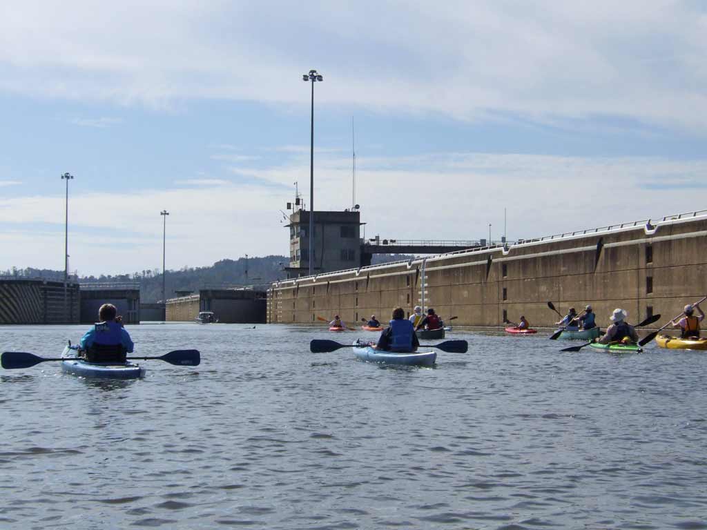
Our group paddles toward the Demopolis Lock.
Our group paddles toward into the Demopolis Lock.
Water level at the start was high.
Water level at the end was low. Those marks on the right side wall are 2 feet apart. The 40+ foot drop of water level took about 15 minutes. Apparently when water is raised, there can besignificant whirlpoolsin this lock. I had no idea what was on the other side of the opening doors. Fast forward in the whirlpool video to about 8:00 in time and hear the guy say, "Holy Crap." I was about to see why he said "Holy Crap" in the video.
For me, going through this Lock was the highlight of this ASRT weekend paddle event. (Sorry Don). Photos don't do this justice. Look on the horizon toward the left on this photo. There are two fishing boats which help to give perspective of the immense size of the spillway.
Swimming was allowed as we took a break on a conveniently located island next to the dam. To see more photos of the Demopolis Dam -Click Here.
Some boaters were fishing for catfish about 50 yards from the spillway.
The roar of the spillway and its sheer size was mesmerizing. There did not appear to be the hazards associated with low-head dams at this Demopolis Dam, but wisely, none of us ventured close enough to find out, not even Billy.
A couple of locals were fishing near the waterfall.
Bob kayaks near the roaring waterfall. What an awesome display of water power.
Numerous great egrets were fishing at the top of the dam where you would think the speed of the water would knock them over.
More egrets.
Anne Cross, always smiling, was instrumental in initially organizing this kayak trip by soliciting the help of Alabama Scenic River Trail (ASRT). Fred Couch, president of ASRT is in the red kayak looking at the waterfall.
On the lower end of the spillway, the waterfall flattens out. A couple of us looked over the potential for doing a little white water kayaking but wisely decided against it as no one had helmets or a true white water kayak. This area looks like it would make a great place for white water play.
Foam trails make designs in the water as they flow downstream.
Not far from the Demopolis Dam, we took out the kayaks at the Lower Pool boat ramp. The USCOE transported the kayaks back to Foscue Creek Park where everyone said their goodbyes. Sure hope we can do it again next year!
Back at Foscue Creek Park, Don Self updated the list of birds documented during this two day event. Several more could be added to the list for me because I saw a Comorant, Great Blue, Osprey Eagle, and a Black Crowned Night Heron while on solo paddles. Demopolis is a great place to get in a kayak or go walking on a trail to do some serious bird watching. A big thumbs up on this event and many thanks go to everyone involved.
2) Superb cloud work. Little did we know a storm was brewing in the Gulf of Mexico.
3) Fog on the Alabama River burnt off quickly.
4) Jacquemontia densely absorbed the morning dew.
5) Everything was wet with dew including this rattlebox wildflower.
6) Golden rod seeds with the damp kayaks in the background.
7) Cleanup after the breakfast. What is missing from these photos are the meals and entertainment both of which were good. I was too busy eating the good food to take photos.
8) Kayakers were beginning to launch and were ready to experience today's dam paddle.
9) The park manager in his power boat cautiously led everyone toward the Claiborne Lock and Dam.
10) Approaching the Claiborne Lock entrance.
11) Entering the lock via the large open doors. Note the waterline color on the wall.
12) Gathering for a group photo. Waters started to recede quickly.
13) The exit doors open inward. Note the water line level now. For perspective, one of the dam workers can be seen on the upper right part of the structure.
14) The last of the kayaks were exiting the lock.
15) Now on the downside of the dam looking up, you can see the water flowing over the submerged dam on the left.
16) Once past the dam, there were occasional sandbars but for the most part, the banks were very silty mud.
17) Unlike the Alabama Port where dock bumpers are relatively low, docks on the Alabama River in this area must tall to accommodate all the different river levels.
18) It is amazing where plants will try to grow.
19) Underwater pipe flow coming from a local paper mill left the water smelling like exactly like a paper mill. (Phew)
20) The US Hwy 84 bridge over Alabama River. It is also the location of the Claiborne Boat Launch which was our exit point and sadly the end of our journey.
21) On the top of the Claiborne boat launch.
So, what was the deal with the Ghost Paddle? If you weren't there, you missed hunting for the Ghost of Nancy on Haines Mountain with real paranormal investigators and yes, we had unexplainable occurrences that were not fabricated.
This three day paddle up around Claiborne Lake on the Alabama River is not really part of the Mobile-Tensaw Delta so it is a bit off topic from the theme of this blog. It is actually part of the Alabama Coosa Tallapoosa Basin. The area is quite remote and beautiful, only about a two hour drive from Mobile and well worth taking a weekend camping trip to explore. For more about this basin, read this PDF by clicking here.
I went up to Isaac Creek Park for the ASRT (Alabama Scenic River Trail) Ghost Paddle event a few hours early to do a little exploring on my own.
1) Isaac Creek boat ramp near Clairborne Lake on the Alabama River near mile 73.
2) Isaac Creek spillway.
3) Thought this sign said 30 feet. 30 feet or 300 feet, neither distance gives me much comfort when it comes to high powered rifles used in hunting. Thankfully, most hunters seem to know not to shoot toward the river.
4) Wow, there are alligators this far upstream.
5) Not sure what these flowers were - looked like a species of smartweed. They sure were abundant.
6) Golden cypress needles made this trip a colorful one.
7) Monarch butterfly working the wildflowers.
8) A Gulf Fritillary butterfly didn't want to leave the few remaining Bur-Marigold flowers.
9) Drinking nectar.
10) As I was returning to the boat ramp after exploring Isaac Creek and an unnamed tributary off the west side of Claiborne Lake at mile 74, Glen and another paddler were launching to check out the current. Here they are after entering the Alabama River.
11) By now, some of the participants in the Ghost Paddle had arrived and were watching the paddlers return.
12) Rattlebox flower with paddlers in the background.
13) Sunset on the Claiborne Lake (Alabama River).
14) Most of the participants in the Ghost Paddle were camping out in tents.