Sunday, March 20, 2005

03/20/2005 - Causeway Public Boat Ramps

Conway Creek - Tensaw River Loop Pedal Trip Summary
50-80 percent chance of rain, but it looked like the storm was splitting up, so I decided to go on a short 3 hour tour. It was cloudy, temp about 60 degrees, winds light, and tide was low. Pedaled at an easy pace, not breathing hard at all.
Launch: Causeway Boat Ramps by Exxon.
Route: Northwest across Chocalata Bay, up Conway Creek, down the Tensaw River to the Battleship, and back to the launch site.
Distance: 11.3 miles.
Average Speed: 3.0 mph.
Time: 3-4 hours.

On the way across Chocalata Bay, there were several groups of Coot paddling around in the water. The tide was low so the passageway up to the Conway Creek turn was narrow. Gulls and sandpipers were plentiful along both sides of the shallow bay. It is a unique experience to be cycling along slowly, getting beneficial exercise, and experiencing nature at its best.


1) Above photo taken from Chocalata Bay looking back toward the Mobile skyline. Alligators made their presence known as soon as I turned up Conway Creek.

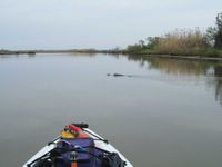
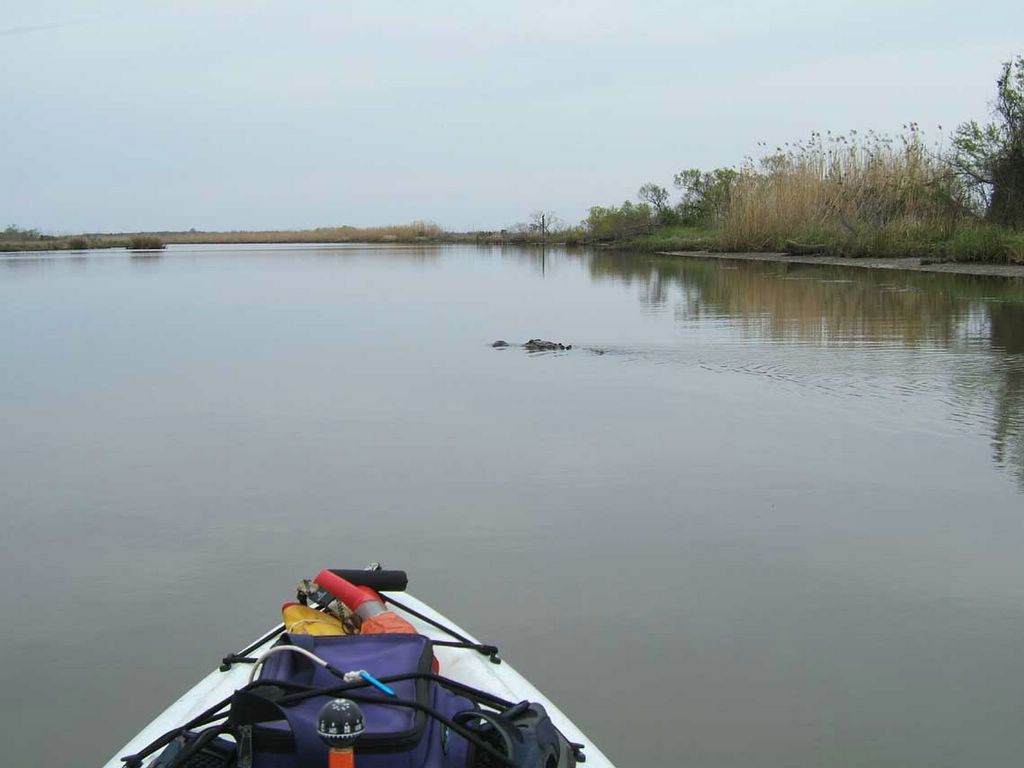
2) Photo shows an alligator pulling out in front of me to get a better look at the pedal kayak. Saw over a dozen alligators along the three mile strech of Conway Creek, most of them slithering slowly off the banks and into the creek as I pedaled by.


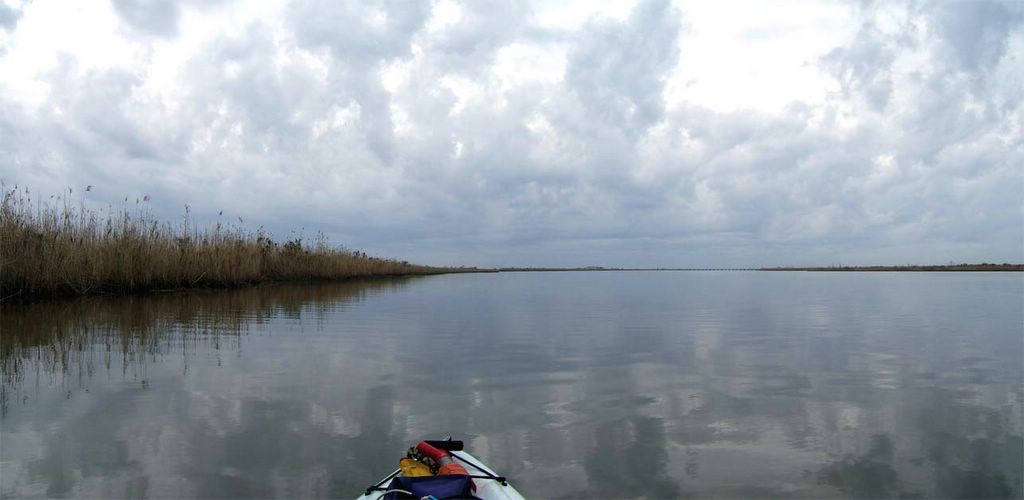
3) The trip down the Tensaw River to the Battleship was beautiful because the waters slicked off, providing some wonderful reflections from the clouds.

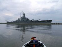
4) Even though I have seen the Battleship USS Alabama hundreds of times, the sheer size of it is best experienced from the water below and I enjoy pedaling by it time after time.

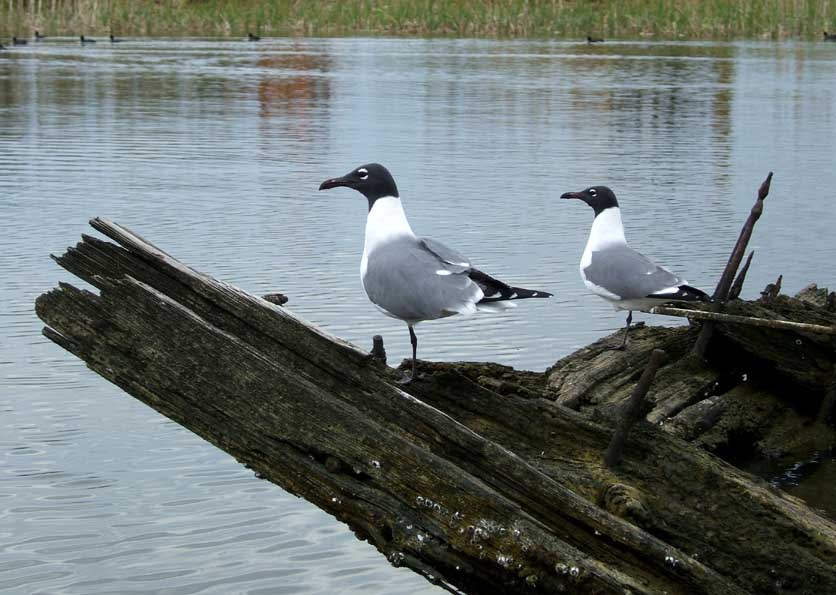
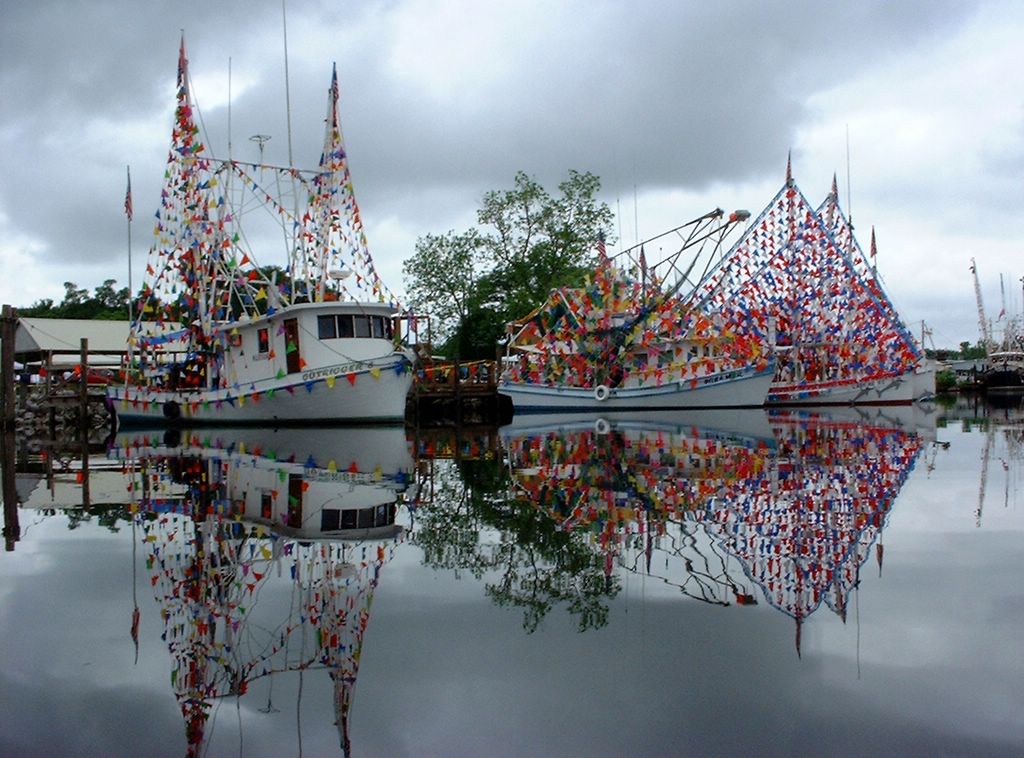
5) On the way back to the launch site, I passed by two gulls perched on an old sunken ship by the docks near the Original Oyster House. The gulls were too lazy to move which allowed me to take a photo of them close up. There are some Coots swimming along the shoreline in the background.

6) Then, on the way around Goat Island, a crowned night heron picked up its head to watch the kayak go by.

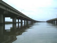
7) The final photo image shows what Interstate I-10 looks like from the kayak. Sure glad I ignored the forecast for rainy weather.

Saturday, March 12, 2005

03/12/2005 - Bayou La Batre Photos

Where is Bayou La Batre? www.mapquest.com/maps/map.adp?searchtype=address&country=US&addtohistory=?&searchtab=home&address=&city=Bayou+La+Batre&state=AL&zipcode

 
Friendly pelicans and colorful shrimp boats in Bayou La Batre 
2004 Blessing of the Fleet and rotting boats on the shore of Bayou La Batre

Treehouse along the banks of Bayou La Batre

Index of Trips (not being maintained any longer - Use Labels instead)


Index of Trips
(no longer updated - Use Labels instead)

Bayou Heron, Grand Bay

  • February 7, 2009 - Bangs Lake

    Bayou La Batre
  • March 12, 2005 - Bayou La Batre
  • May 1, 2005 - Blessing of the Fleet Club Trip
  • May 1, 2005 - Blessing of the Fleet Parade
  • November 12, 2005 - Bayou La Batre
  • March 12, 2006 - Bayou La Batre
  • March 19, 2006 - Bayou La Batre
  • May 7, 2006 - Blessing of the Fleet

    Billy's Hwy 43
  • September 13, 2009 - Chickasaw Creek

    Boathouse Landing
  • July 17, 2005 - Pinelog Creek, Holly Creek

    Bon Secour
  • December 10, 2005 - Bon Secour

    Buzbees Landing
  • April 23, 2005 - Bay Minette Creek
  • May 21, 2005 - Bay Minette Basin
  • January 28, 2006 - Bay Minette Creek
  • March 18, 2006 - Bay Minette Creek
  • August 13, 2006 - Bay Minette Creek
  • September 17, 2007 - Bay Minette Basin
  • January 17, 2009 - Bay Minette Creek
  • February 22, 2009 - Bay Minette Creek
  • September 24, 2009 - Bay Minette Creek

    Brynes Lake
  • May 8, 2005 - Brynes Lake, Tensaw River
  • May 15, 2005 - Red Hill Creek
  • May 28, 2005 - Byrnes Lake, McVay Lake
  • May 14, 2006 - Big Briar Creek
  • December 29, 2006 - Briar Creek Tributary
  • January 11, 2009 - Gravine Island

    Causeway
  • March 20, 2005 - Conway Creek
  • May 6, 2005 - Chocalata Bay
  • May 14, 2005 - Conway Creek
  • June 5, 2005 - Mobile River
  • July 3, 2005 - Bay Grass
  • July 16, 2005 - Bay Grass
  • July 30, 2005 - Little Bateau
  • August 4, 2005 - Pass Picada
  • October 16, 2005 - Tensaw River
  • November 6, 2005 - Mobile River
  • January 21, 2006 - Chocalata Bay
  • February 27, 2006 - Red Maple Slough
  • March 4, 2006 - Mobile River
  • May 20, 2006 - Mobile River
  • June 11, 2006 - Big Bay John
  • August 26, 2006 - Pass Picada
  • September 2, 2006 - Pass Picada
  • September 3, 2006 - Mobile River
  • October 10, 2006 - Mobile River
  • October 21, 2006 - Conway Creek, Lower Crab Creek
  • November 24, 2006 - Conway Creek, Lower Crab Creek
  • January 1, 2007 - Mobile River Fireworks
  • December 30, 2008 - 5-Rivers
  • January 1, 2009 - Mobile River
  • January 24, 2009 - Bay Grass
  • March 7, 2009 - Red Maple Slough
  • April 25, 2009 - Garrow's Bend
  • September 19, 2009 - Lower Crab Creek and tributaries
  • September 26, 2009 - Mobile River Loop
  • October 6, 2009 - Whiskey Ditch

    Cliff's Landing
  • March 11, 2006 - Red Hill Creek
  • March 11, 2006 - Red Hill Creek
  • April 16, 2006 - Dennis Creek
  • May 6, 2006 - Smith Bayou
  • June 17, 2006 - Owl Creek and Maple Creek
  • June 24, 2006 - Dennis Creek Tributary
  • October 29, 2006 - Dennis Creek Tributary
  • October 8, 2009 - Mifflin Lake


    Cloverleaf
  • May 14, 2005 - Half Mile Bayou
  • March 25, 2006 - Cable Creek
  • July 8, 2006 - Chuckfee Bay - Mallard Fork
  • December 16, 2006 - Three Mile Creek

    Converse Reservoir
  • November 19, 2005 - Converse Reservoir
  • October 1, 2006 - Converse Reservoir

    Dauphin Island
  • May 21, 2005 - Sand Island
  • June 4, 2005 - Sand Island
  • June 12, 2005 - Sand Island
  • June 19, 2005 - Sand Island
  • July 2, 2005 - Sand Island
  • August 7, 2005 - Fort Morgan, Sand Island
  • August 14, 2005 - Sand Island
  • October 1, 2005 - Sand Island
  • November 20, 2005 - Sand Island
  • January 22, 2006 - Little Dauphin Island
  • February 5, 2006 - Sand Island
  • March 5, 2006 - Sand Island
  • April 2, 2006 - Sand Island
  • May 21, 2006 - Fort Morgan, Sand Island
  • August 12, 2006 - Sand Island
  • August 20, 2006 - Sand Island
  • August 27, 2006 - Sand Island
  • September 4, 2006 - Sand Island
  • September 9, 2006 - Pelican Bay
  • September 23, 2006 - Sand Island
  • November 23, 2006 - Sand Island
  • January 4, 2009 - Sand Island

    Dead Lake Marina
  • September 29, 2009 - Mobile River

    Dog River Park, formerly Luscher Park
  • June 25, 2005 - Dog River Dog Paddle Races
  • October 22, 2005 - Dog River
  • June 10, 2006 - Dog River Dog Paddle Races
  • September 24, 2006 - Dog River
  • February 14, 2009 - Dog River and Eslavia Creek
  • March 25, 2009 - Halls Mill Creek
  • March 28, 2009 - Dog River
  • May 16, 2009 - Dog River Dog Paddle Races

    Fairhope
  • April 19, 2005 - Fairhope Pier, Earth Day
  • May 30, 2005 - Mobile Bay, Fly Creek
  • June 18, 2005 - Fairhope Pier, Grandman Triathlon
  • November 5, 2005 - Mobile Bay
  • April 23, 2006 - Fairhope Pier, Earth Day
  • June 3, 2006 - Fairhope Pier, Grandman Triathlon
  • December 31, 2008 - Fairhope Yacht Club - New Years Eve
  • May 30, 2009 - Fairhope Yacht Club, Grandman Triathlon, Fly Creek

    Hoppe's Landing
  • December 2, 2006 - Dog River Christmas Parade
  • April 19, 2009 - Alligator Bayou
  • October 1, 2009 - Gaillard Island, Theodore Industrial Canal aka TIC

    Hurricane Landing
  • May 22, 2005 - Hurricane Bayou, Tensaw River

    John's Launch
  • April 10, 2009 - Rabbit Creek

    Little Lagoon Pass
  • November 25, 2006 - Little Lagoon

    Macintosh Olin Landing
  • May 13, 2006 - Tombigbee River

    McNally Park
  • August 13, 2005 - Mobile Bay, Gaillard Island
  • September 10, 2007 - Mobile Bay, Gaillard Island, TIC

    Meaher Park
  • June 15, 2005 - Ducker Bay
  • April 9, 2006 - Ducker Bay

    Memories Fishing Camp
  • April 24, 2005 - Fowl River
  • April 28, 2005 - Fowl River
  • May 11, 2005 - Fowl River
  • June 30, 2005 - Fowl River
  • July 19, 2005 - Fowl River
  • July 4, 2006 - Fowl River

    Mt. Vernon Landing
  • August 6, 2005 - Mobile River, Cedar Creek

    Mullet Point
  • September 30, 2006 - Middle Bay Lighthouse

    Perdido Pass
  • December 17, 2006 - Orange Beach

    Poticaw Landing
  • April 22, 2006 - Wards Bayou

    Rice Creek
  • July 31, 2005 - Rice Creek, Briar Lake, Tensaw Lake
  • June 18, 2006 - Bayou Tallapoosa
  • March 8, 2009 - Bayou Tallapoosa
  • April 18, 2009 - Bayou Jessamine and Champion Bald Cypress

    Service Park Landing, Coffeeville Dam
  • May 2, 2009 - Choctaw National Wildlife Refuge

    Shingle Mill Landing
  • October 10, 2009 - Lower Escatawpa River

    Steele Creek Park
  • July 4, 2005 - Steele Creek, Black Creek
  • April 1, 2006 - Little Catfish Bayou
  • January 31, 2009 - Steele Creek
  • January 31, 2009 - Gunnison Creek
  • February 21, 2009 - Gunnison Creek
  • September 30, 2009 - Black Creek

    William Brooks Park (Formerly Tucker's Landing)
  • April 3, 2005 - Chickasaw Creek, LST 325, Pumphouse Canal
  • April 29, 2005 - Chickasaw Creek, Pumphouse Canal
  • May 29, 2005 - Chickasaw Creek, Mobile River
  • June 21, 2005 - Chickasaw Creek, Greenwood Bayou
  • August 2, 2005 - Chickasaw Creek
  • August 3, 2005 - Chickasaw Creek
  • January 29, 2006 - Chickasaw Creek
  • May 13, 2006 - Chickasaw Creek
  • November 26, 2006 - Chickasaw Creek
  • December 3, 2006 - Black Creek
  • December 29, 2008 - Chickasaw Creek
  • December 30, 2008 - Pumphouse Canal
  • February 8, 2009 - Pumphouse Canal
  • April 3, 2009 - Chickasaw Creek and Pumphouse Canal
  • 03/12/05 - Welcome to Rob's Blog

    Hello! Welcome to Rob's Blog.

    The objective of this blog is to share some of my experiences paddling and pedaling in the Mobile-Tensaw River Delta, including Mobile Bay, and the Barrier Islands. Hopefully it will entice some of you to get out and experience your own kayaking adventures.

    This blog also serves as a historical archive of sorts. A few years ago, you could paddle up to and touch the anchor of the Battleship USS Alabama whereas now, the Battleship is enclosed by a sea wall. The LST-325 spent some time off Chickasaw Creek and now it is gone for good. Same with people. One day you're enjoying the company of someone like Larry McDuff and then next day he is gone. Photos help us to remember people. Skylines constantly change, shorelines change, etc., so what is shown in the photos that you see now, will probably not be the same decades and centuries from now. Future generations can look back at the content of some of these blogs, if the content still exists, and either admire or be sickened by the way we live today. Perhaps they can even learn from our history.

    The photos on this blog have all been drastically reduced in size to save space and help speed up display, not to mention the reduced size curtails the use of printing these photos should someone want to steal the photos for their own profit. If you have a particular need to print any of these, I still have most of the unedited photos.

    Last but not least, this is a blog, a novel idea not even a decade old. Where will the content of this blog go when I'm dead and gone and no one is editing or adding to it anymore? Many free internet sites in the past disappeared after the company went bankrupt. So, if you see photos you want for a screen saver or something, by all means, get them while you can. No one knows how long Blogger will remain active.

    Anyway, I hope you enjoy the adventures in this kayaking photo blog. Comments are welcome.

    Rob