Friday, July 22, 2011

07/22/2011 - Little River

Launch: Bayou la Batre Public Launch
Launch Cost: Free
Destination: Explore Little River and also Grand Bayou. The trip (my first) up Little River was well worth it. To paddle all the way up Little River is an 8 mile round trip from Bayou La Batre. The paddle up Grand Bayou was a waste of time.
Distance: 18 miles (round trip)
Paddle time: 6-1/2 hours
Weather: 80-90 degrees. Winds variable with occasional gusts during storms. Current was minimal, tide was going out with minimal change. Water temp about 86 degrees. Seas 1 at the start and eventually slicking off.
Caution Note: Portersville Bay (Mississippi Sound) is open water and strong winds can create choppy seas. Take a spray skirt!
GPS Track: To view or download the GPS track of this trip, Click Here.


Header image is a photo of yet another storm. This one produced lightning. Time to get off the water!

1) Photomerge of a wild looking sunrise as seen from Portersville Bay. If you squint at the distant horizon on the right side of the photo, you can see a couple of kayakers who were fishing. This was a superb sunrise.

2) There was typical low growth grasses and needle rush in the salt marsh near the entrance to Little River. I was surprised to see an alligator in this area. Saw quite a few alligators today.

3) After about a mile up Little River, the salt marsh grasses are replaced by a low pine tree savannah with palmettos - part of the Grand Bay Swamp.

4) Further up Little River is a forest of dead pine trees. Little River is quiet little jewel, beautiful, and very clean. Only saw one RV home - the rest is all nature.

5) Based on the forecast, I brought the umbrella and it came in handy a few times during brief showers.

6) This is a salt flat area with a lot of crab activity. Crabs create tiny sand balls as they clean the sand. The balls help them identify what sand has been cleaned and what needs to be cleaned.

7) The sun finally came out (along with the heat) and the waters slicked off making for a pleasantly hot paddle.

8) Sometimes distant storms made the horizon blend in together so it was hard to tell where the water ended and the sky began.

9) What you see here is a double row of wave attenuator units that is part of the Little Bay Marsh Restoration Project. The attenuators help protect the Little Bay area, now restored, which was devastated (washed away) by Hurricane Katrina.

10) If you like birding, the area behind these wave attenuators provide sanctuary to a wide variety of shore birds. Take your binoculars.

11) This oyster catcher can thank the Alabama Department of Conservation and Natural Resources and Volkert Engineering for its restored habitat.

12) A tern speaking ternese and roughly translated it said, "It is hot."

13) A tenth of a mile up Bayou La Batre River a multitude of little crabs were cleaning the sand, at least the area that wasn't covered with trash.

 14) Of course, when it comes to Bayou La Batre, much of the shoreline will be trashy.

Wednesday, July 20, 2011

07/20/2011 - Dog River Sunrise Pedal

Header image is a photo of Dog River Bridge.

1) Sunrise over Mobile Bay.

2) There was a flock of seagulls feeding on shrimp or minnows.

3) More birds feeding.

Monday, July 18, 2011

07/18/2011 - Dog River Sunrise Pedal

Header image is a photo of higher waves due to tidal current activity near the mouth of Dog River.

1) No visible sunrise this morning thanks to cooling cloud cover.

2) Happy Birthday to Robert Hooke, inventor extraordinaire. Hooke was the first meteorologist to keep records. Speaking of records, Mobile, AL had a record streak of 50 consecutive days with temperatures over 90 degrees that ended on July 16 when rainy weather kept the temperatures down to a high of 82 degrees. The previous record was 35 consecutive days in 1999.

3) Tree trunks were partially wet with moisture.

4) By the end of the paddle this morning, a small rainbow appeared in the sky and the clouds started giving way to blue skies.

Saturday, July 16, 2011

07/16/2011 - Upper Dog River

The inquisitive eyes of a cat that seemed to have never seen a kayak before.

1) A green heron cautiously eyes the kayak as it goes by.

2) The baby Muscovy ducks are starting to get some red on their face.

3) There was a big party at Martin's house.

4) An Osprey Eagle displays the catch of the day for the camera.

5) It is about impossible to paddle in upper Dog River without seeing signs of Mobile's illegal trash dump.

6) Ducks get no environmental respect in upper Dog River.

7) To a passing boater, the shoreline in this photo looks pretty clean, right?

8) If you look in behind the shore vegetation at this spot, the view is entirely different. Hope is not lost - there is a Coastal Cleanup scheduled for September 17th. Please consider volunteering to get out in a kayak on Dog River on Sept. 17th to pick up a few bags of trash. Thanks.

9) A couple of young kids enjoy a cloudy Saturday afternoon fishing in Rabby Creek.

10) A father and son enjoy a Saturday afternoon kayaking in Dog River. See the goose?

Thursday, July 14, 2011

07/14/2011 - Cedar Creek & Barrow Creek

Launch: Cedar Creek Landing east of Movico, AL
Launch Cost: $5
Destination: Exploratory paddle of Cedar Creek, Louis Lake, David Lake, Sheppard Lake and and Barrow Creek. To paddle the David Lake-Sheppard Lake area, use the Mt Vernon Launch site because it is closer and free. I paddled up Cedar Creek, Louis Lake and Barrow Creek until log jams blocked the way.
Distance: 28 miles (round trip)
Paddle time: 9-1/2 hours
Weather: Foggy until 9:00 am and then it was another hot day in Alabama. Mostly Sunny. Rising tide. Minimal (<0.5 mph) current. No waves. No wind.
GPS Track: To view or download the GPS track of this trip, Click Here.
Header image is a photo of the Barrow Creek area which sees frequent flooding.

1) No sunrise this morning where on Mobile River, the fog kept the temperatures cool until about 9:00 a.m.

2) The first place I explored was Louis Lake which reminded me a little of Bayou Jessamine. There was a green coating on the water surface. An alligator scurried out of the water and ran into the woods.

3) I paddled north to David Lake where there is a little bit of industrial activity. Many of the shoreline trees have been roped to death by barges.

4) From David Lake I paddled into Sheppard Lake where there were a lot of people fishing for brim.

5) Sheppard Lake leads to Barrow Creek where I found some big trees. I'm about to paddle through the middle of this weathered cypress tree.

6) One cypress tree in Barrow Creek seemed to be out of place because its trunk was so big compared to the trees around it. It reminded me a little of the champion cypress.

7) Saw quite a few Swallow-Tailed Kites and plenty of these Prothonotary Warblers.

8) Back on the Mobile River, a large pleasure boat motored past leaving a 3 foot wake that caused bank erosion. Ironically, contractors can get fined if they cause erosion and turbid waters. What is ADEM doing about erosion caused by boats?

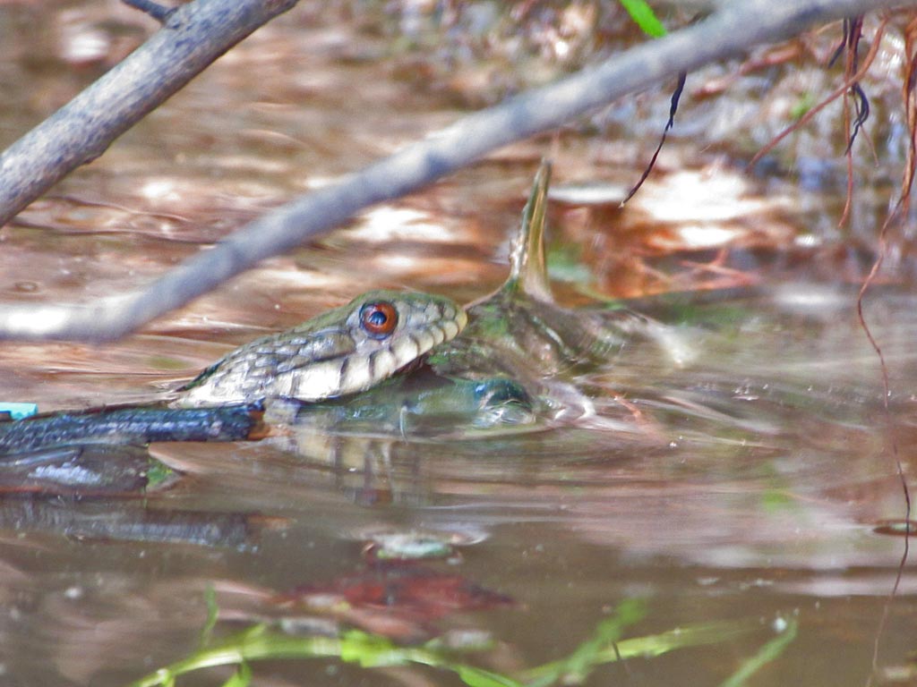
9) Saw a lot of snakes today and this watersnake in Mobile River had caught a fish.

10) It swam to the bank with the rather large catfish and proceeded to try to swallow it whole. Note the catfish barb sticking up.

11) There were a lot of turtles out on logs letting the sun dry out their algae caked shells.

12) How the expired turtle ended up like this stumps me.

13) Up in Cedar Creek there were a couple of deer in the swamp grasses.

14) Just beyond Cedar Creek Landing is a houseboat community with a neat direction sign.